
~ Dix Creek AZ topo map, 1:24000 scale, 7.5 X 7.5 Minute, Historical, 1997, updated 2000
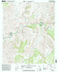
Dix Creek, Arizona, USGS topographic map dated 1997.
Includes geographic coordinates (latitude and longitude). This topographic map is suitable for hiking, camping, and exploring, or framing it as a wall map.
Printed on-demand using high resolution imagery, on heavy weight and acid free paper, or alternatively on a variety of synthetic materials.
Topos available on paper, Waterproof, Poly, or Tyvek. Usually shipping rolled, unless combined with other folded maps in one order.
- Product Number: USGS-5551530
- Free digital map download (high-resolution, GeoPDF): Dix Creek, Arizona (file size: 15 MB)
- Map Size: please refer to the dimensions of the GeoPDF map above
- Weight (paper map): ca. 55 grams
- Map Type: POD USGS Topographic Map
- Map Series: HTMC
- Map Verison: Historical
- Cell ID: 12358
- Scan ID: 311150
- Imprint Year: 2000
- Woodland Tint: Yes
- Aerial Photo Year: 1992
- Edit Year: 1997
- Survey Year: 1957
- Datum: NAD27
- Map Projection: Transverse Mercator
- Map published by United States Geological Survey
- Map published by United States Forest Service
- Map Language: English
- Scanner Resolution: 600 dpi
- Map Cell Name: Dix Creek
- Grid size: 7.5 X 7.5 Minute
- Date on map: 1997
- Map Scale: 1:24000
- Geographical region: Arizona, United States
Neighboring Maps:
All neighboring USGS topo maps are available for sale online at a variety of scales.
Spatial coverage:
Topo map Dix Creek, Arizona, covers the geographical area associated the following places:
- Salt Ground Tank - Ridge Tank - Hamilton Mesa Corral - Point Spring - Dix Mesa Number One Tank - Middle Tank - Beehive Tank - Sunflower Mesa - Pat Creek - Lower Bull Tank - Sunflower Mesa Tank - Greenlee County - Red Tank Canyon - Blue Holes Spring - Table Top - Seep Spring - Saltground Tank - Maverick Spring - Bird Canyon - Oak Canyon - Martinez Ranch - Mesa Corral - Burro Mesa - Blue River - Hickey Canyon - Fence Tank - Lightning Mesa Tank - Oak Spring - Bull Canyon Tank - Hamilton Canyon - Frisco Bluff Spring - Hackberry Gulch - Sunflower Corral - Dix Creek Corral - Lightening Mesa Corral - Red Flats Tank - White Rock Canyon - Yellow Jacket Spring - North Pat Mesa Tank - Canyon Corral - Mesquite Flat - White Rock Spring - Pleasant Valley - Bobby Tank - Dix Mesa Number Two Tank - Grapevine Spring - Hog Canyon - Hog Canyon Spring - Pleasant Valley Tank Number Two - The Hole - Lightening Mesa Tank - Sunflower Tank - Blow Out Spring - Zumwalt Corner Tank - Antelope Mesa - Curly Tank - Bull Saddle - Pat Corral - Number Two Tank - Sunset Spring - Lower Buckhorn Tank - Upper Hog Canyon Tank - Bee Mesa - Hamilton Tank - Dix Mesa Tank - N Pat Corral - Salt Ground Canyon - Brushy Tank - Burro Mesa Tank - Rock Basin Spring - Dix Creek - Bloody Canyon Tank - Draw Tank - Shake Spring - Sardine Creek - Basin Tank - Brushy Tanks Number One - Snake Ridge - Pleasant Valley Tank - Big Tank Series - Malpais Spring - Big Buckhorn Tank - Boulder Tank - Lightning Mesa - Red Tank Corral - Yolk Spring - Big Tank Series Number One - Bootleg Saddle - Trail Tank - Bull Canyon - Snake Ridge Tank - Lone Tree Mesa - Chinaberry Tank - Mesquite Tank - Seep Spring - Right Prong Dix Creek - Yellowjacket Tank - Salt Ground Corral - Harden Cienega Creek - Johnnie Tank
- Map Area ID: AREA33.2533.125-109.25-109.125
- Northwest corner Lat/Long code: USGSNW33.25-109.25
- Northeast corner Lat/Long code: USGSNE33.25-109.125
- Southwest corner Lat/Long code: USGSSW33.125-109.25
- Southeast corner Lat/Long code: USGSSE33.125-109.125
- Northern map edge Latitude: 33.25
- Southern map edge Latitude: 33.125
- Western map edge Longitude: -109.25
- Eastern map edge Longitude: -109.125


