
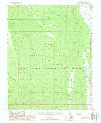
~ De Motte Park AZ topo map, 1:24000 scale, 7.5 X 7.5 Minute, Historical, 1988, updated 1988
De Motte Park, Arizona, USGS topographic map dated 1988.
Includes geographic coordinates (latitude and longitude). This topographic map is suitable for hiking, camping, and exploring, or framing it as a wall map.
Printed on-demand using high resolution imagery, on heavy weight and acid free paper, or alternatively on a variety of synthetic materials.
Topos available on paper, Waterproof, Poly, or Tyvek. Usually shipping rolled, unless combined with other folded maps in one order.
- Product Number: USGS-5551428
- Free digital map download (high-resolution, GeoPDF): De Motte Park, Arizona (file size: 13 MB)
- Map Size: please refer to the dimensions of the GeoPDF map above
- Weight (paper map): ca. 55 grams
- Map Type: POD USGS Topographic Map
- Map Series: HTMC
- Map Verison: Historical
- Cell ID: 11540
- Scan ID: 311100
- Imprint Year: 1988
- Woodland Tint: Yes
- Visual Version Number: 1
- Aerial Photo Year: 1982
- Edit Year: 1988
- Field Check Year: 1984
- Datum: NAD27
- Map Projection: Transverse Mercator
- Provisional map: Yes
- Map published by United States Geological Survey
- Map Language: English
- Scanner Resolution: 600 dpi
- Map Cell Name: De Motte Park
- Grid size: 7.5 X 7.5 Minute
- Date on map: 1988
- Map Scale: 1:24000
- Geographical region: Arizona, United States
Neighboring Maps:
All neighboring USGS topo maps are available for sale online at a variety of scales.
Spatial coverage:
Topo map De Motte Park, Arizona, covers the geographical area associated the following places:
- Deer Lake - Dry Park Lakes - South Blow Down Tank - Indian Lake - Lookout Lakes - North Blow Down Tank - West Blow Down Tank - Dry Park Apron - V T Hill - Dry Park Lookout - Blow Down Tank - De Motte Park - Kaibab Lodge - V T Lake - V T Ridge Number One Tank - V T Ridge Number Two Tank - DeMotte Campground - V T Park Landing Strip (historical) - Blowdown Tank - The Blowdown - Cougar Lake - Dry Park - Browns Canyon Tank - Aspen Tank
- Map Area ID: AREA36.536.375-112.25-112.125
- Northwest corner Lat/Long code: USGSNW36.5-112.25
- Northeast corner Lat/Long code: USGSNE36.5-112.125
- Southwest corner Lat/Long code: USGSSW36.375-112.25
- Southeast corner Lat/Long code: USGSSE36.375-112.125
- Northern map edge Latitude: 36.5
- Southern map edge Latitude: 36.375
- Western map edge Longitude: -112.25
- Eastern map edge Longitude: -112.125


