
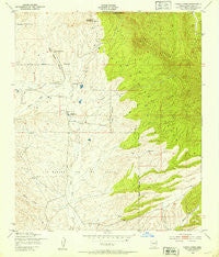
~ Canelo Pass AZ topo map, 1:24000 scale, 7.5 X 7.5 Minute, Historical, 1948, updated 1953
Canelo Pass, Arizona, USGS topographic map dated 1948.
Includes geographic coordinates (latitude and longitude). This topographic map is suitable for hiking, camping, and exploring, or framing it as a wall map.
Printed on-demand using high resolution imagery, on heavy weight and acid free paper, or alternatively on a variety of synthetic materials.
Topos available on paper, Waterproof, Poly, or Tyvek. Usually shipping rolled, unless combined with other folded maps in one order.
- Product Number: USGS-5550674
- Free digital map download (high-resolution, GeoPDF): Canelo Pass, Arizona (file size: 11 MB)
- Map Size: please refer to the dimensions of the GeoPDF map above
- Weight (paper map): ca. 55 grams
- Map Type: POD USGS Topographic Map
- Map Series: HTMC
- Map Verison: Historical
- Cell ID: 7045
- Scan ID: 310720
- Imprint Year: 1953
- Woodland Tint: Yes
- Aerial Photo Year: 1946
- Field Check Year: 1948
- Datum: NAD27
- Map Projection: Polyconic
- Map published by United States Geological Survey
- Map published by United States Army Corps of Engineers
- Map published by United States Army
- Map Language: English
- Scanner Resolution: 600 dpi
- Map Cell Name: Canelo Pass
- Grid size: 7.5 X 7.5 Minute
- Date on map: 1948
- Map Scale: 1:24000
- Geographical region: Arizona, United States
Neighboring Maps:
All neighboring USGS topo maps are available for sale online at a variety of scales.
Spatial coverage:
Topo map Canelo Pass, Arizona, covers the geographical area associated the following places:
- Middle Canyon Tank - Pauline Stock Tank - Max Tank - Mansunita - Mowry Wash - Jones Ranch - Sheep Ranch Canyon - San Rafael de la Zanja - Dan Tank - Bishop Tank - Paloma Spring - Middle Canyon Corral - Little Outfit Ranch - Chino Draw - Cherry Creek - Vaca Ranch - Leslie Tank - Lookout Knoll - Bide Spring - Fritz Tank - A Bar Draw - Ki-He-Kah Ranch - Sierra Vista Ranger District - Headquarters Tank - Williamson Tank - Silver Tank Storage - Dove Tank - Korn Well - San Rafael (historical) - Cott Tank - East Forest Well - Bailey Ranch - San Rafael Valley - Silver Tank - Bog Hole Tank - Home Tank - Dove Canyon - Middle Canyon Spring - A Bar Draw Tank - Jack Tank - Baldwin Tank - Jones Canyon - Rosemary Tank - Bear Tank
- Map Area ID: AREA31.531.375-110.625-110.5
- Northwest corner Lat/Long code: USGSNW31.5-110.625
- Northeast corner Lat/Long code: USGSNE31.5-110.5
- Southwest corner Lat/Long code: USGSSW31.375-110.625
- Southeast corner Lat/Long code: USGSSE31.375-110.5
- Northern map edge Latitude: 31.5
- Southern map edge Latitude: 31.375
- Western map edge Longitude: -110.625
- Eastern map edge Longitude: -110.5


