
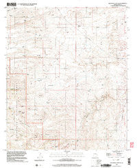
~ Buehman Canyon AZ topo map, 1:24000 scale, 7.5 X 7.5 Minute, Historical, 1996, updated 2003
Buehman Canyon, Arizona, USGS topographic map dated 1996.
Includes geographic coordinates (latitude and longitude). This topographic map is suitable for hiking, camping, and exploring, or framing it as a wall map.
Printed on-demand using high resolution imagery, on heavy weight and acid free paper, or alternatively on a variety of synthetic materials.
Topos available on paper, Waterproof, Poly, or Tyvek. Usually shipping rolled, unless combined with other folded maps in one order.
- Product Number: USGS-5550514
- Free digital map download (high-resolution, GeoPDF): Buehman Canyon, Arizona (file size: 12 MB)
- Map Size: please refer to the dimensions of the GeoPDF map above
- Weight (paper map): ca. 55 grams
- Map Type: POD USGS Topographic Map
- Map Series: HTMC
- Map Verison: Historical
- Cell ID: 5990
- Scan ID: 310637
- Imprint Year: 2003
- Woodland Tint: Yes
- Aerial Photo Year: 1996
- Datum: NAD83
- Map Projection: Universal Transverse Mercator
- Map published by United States Geological Survey
- Map Language: English
- Scanner Resolution: 600 dpi
- Map Cell Name: Buehman Canyon
- Grid size: 7.5 X 7.5 Minute
- Date on map: 1996
- Map Scale: 1:24000
- Geographical region: Arizona, United States
Neighboring Maps:
All neighboring USGS topo maps are available for sale online at a variety of scales.
Spatial coverage:
Topo map Buehman Canyon, Arizona, covers the geographical area associated the following places:
- Old Dirt Tank - Pink Tank - Brush Corrals - Pipeline Spring - Poppy Well - Peck Spring - Red Tank - Davis Spring Trail Twenty-eight - Buehman Canyon - Pabasco Tank - Diablo Canyon - Split Tank - Georges Spring - Limestone Well - Cottonwood Cove Spring - Burleson Well - Rock Tank - Pearsons Spring - Lone Hill - Mesa Well - Cocklebur Tank - Bullock Canyon - Lonehill Tank - White Tank - Burro Creek - OF Parker Ranch - Deep Well - Cedar Spring - Mesquite Flat Spring - Donovan Tank
- Map Area ID: AREA32.532.375-110.625-110.5
- Northwest corner Lat/Long code: USGSNW32.5-110.625
- Northeast corner Lat/Long code: USGSNE32.5-110.5
- Southwest corner Lat/Long code: USGSSW32.375-110.625
- Southeast corner Lat/Long code: USGSSE32.375-110.5
- Northern map edge Latitude: 32.5
- Southern map edge Latitude: 32.375
- Western map edge Longitude: -110.625
- Eastern map edge Longitude: -110.5


