
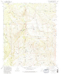
~ Buckhead Mesa AZ topo map, 1:24000 scale, 7.5 X 7.5 Minute, Historical, 1973, updated 1986
Buckhead Mesa, Arizona, USGS topographic map dated 1973.
Includes geographic coordinates (latitude and longitude). This topographic map is suitable for hiking, camping, and exploring, or framing it as a wall map.
Printed on-demand using high resolution imagery, on heavy weight and acid free paper, or alternatively on a variety of synthetic materials.
Topos available on paper, Waterproof, Poly, or Tyvek. Usually shipping rolled, unless combined with other folded maps in one order.
- Product Number: USGS-5550490
- Free digital map download (high-resolution, GeoPDF): Buckhead Mesa, Arizona (file size: 12 MB)
- Map Size: please refer to the dimensions of the GeoPDF map above
- Weight (paper map): ca. 55 grams
- Map Type: POD USGS Topographic Map
- Map Series: HTMC
- Map Verison: Historical
- Cell ID: 5915
- Scan ID: 310624
- Imprint Year: 1986
- Woodland Tint: Yes
- Aerial Photo Year: 1965
- Field Check Year: 1973
- Datum: NAD27
- Map Projection: Transverse Mercator
- Map published by United States Geological Survey
- Map published by United States Forest Service
- Map Language: English
- Scanner Resolution: 600 dpi
- Map Cell Name: Buckhead Mesa
- Grid size: 7.5 X 7.5 Minute
- Date on map: 1973
- Map Scale: 1:24000
- Geographical region: Arizona, United States
Neighboring Maps:
All neighboring USGS topo maps are available for sale online at a variety of scales.
Spatial coverage:
Topo map Buckhead Mesa, Arizona, covers the geographical area associated the following places:
- Whiterock Corral - Pilot Knob Tank - Horsethief Tank - Connally Point Tank - Brushy Basin Tank - Oak Spring - Pilot Knob - Cypress Canyon - Red Rock Tank - White Tank - White Mountain Mine - Red Rock Spring - Buckhead Draw - Pine Ridge Tank - Walnut Spring - Ridge Tank - Bee Seep Tank - Point Tank - Juniper Tank - Contact Spring - Crackerjack Ridge - Crackerjack Mine - Brushy Canyon - Cedar Flat - Maverick Flat - Bradshaw Tank - Cedar Flat Tank - Black Mesa - White Hills - Tonto Natural Bridge State Park - Crackerjack Tank - Rock Canyon - Bear Canyon - Summit Spring - Brushy Basin - Point Tank - Clover Spring - Dead Cow Canyon - Gowan Mine - Red Hill Tank - Oak Spring Canyon - Contact Canyon - White Mountain Tank - Pine Trailhead - South Walnut Spring - Tonto Natural Bridge - Contact Trick Tank - Tank Gulch Tank - Buckhead Tank - Cedar Mesa - Buckhead Mesa - Connally Point - Cedar Mesa Tank - White Mountain - Horsethief Bench - White Hills Tank - Limestone Tank - Big Tank - Thirtysix Tank - East Walnut Canyon - Donahue Tank - Tip Tank - Pine Ridge - Cedar Mesa Canyon - Dripping Springs - The Narrows - East Tank - Walnut Canyon - Bridge Tank - Tank Gulch - Brushy Tank - Crackerjack Mesa - Water Spring - Maverick Flat Tank - Summit Mine - Buckhead Canyon - Buckhead Tank
- Map Area ID: AREA34.37534.25-111.5-111.375
- Northwest corner Lat/Long code: USGSNW34.375-111.5
- Northeast corner Lat/Long code: USGSNE34.375-111.375
- Southwest corner Lat/Long code: USGSSW34.25-111.5
- Southeast corner Lat/Long code: USGSSE34.25-111.375
- Northern map edge Latitude: 34.375
- Southern map edge Latitude: 34.25
- Western map edge Longitude: -111.5
- Eastern map edge Longitude: -111.375


