
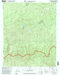
~ Brookbank Point AZ topo map, 1:24000 scale, 7.5 X 7.5 Minute, Historical, 1998, updated 2001
Brookbank Point, Arizona, USGS topographic map dated 1998.
Includes geographic coordinates (latitude and longitude). This topographic map is suitable for hiking, camping, and exploring, or framing it as a wall map.
Printed on-demand using high resolution imagery, on heavy weight and acid free paper, or alternatively on a variety of synthetic materials.
Topos available on paper, Waterproof, Poly, or Tyvek. Usually shipping rolled, unless combined with other folded maps in one order.
- Product Number: USGS-5550414
- Free digital map download (high-resolution, GeoPDF): Brookbank Point, Arizona (file size: 13 MB)
- Map Size: please refer to the dimensions of the GeoPDF map above
- Weight (paper map): ca. 55 grams
- Map Type: POD USGS Topographic Map
- Map Series: HTMC
- Map Verison: Historical
- Cell ID: 5609
- Scan ID: 310586
- Imprint Year: 2001
- Woodland Tint: Yes
- Aerial Photo Year: 1992
- Edit Year: 1998
- Datum: NAD27
- Map Projection: Transverse Mercator
- Map published by United States Geological Survey
- Map published by United States Forest Service
- Map Language: English
- Scanner Resolution: 600 dpi
- Map Cell Name: Brookbank Point
- Grid size: 7.5 X 7.5 Minute
- Date on map: 1998
- Map Scale: 1:24000
- Geographical region: Arizona, United States
Neighboring Maps:
All neighboring USGS topo maps are available for sale online at a variety of scales.
Spatial coverage:
Topo map Brookbank Point, Arizona, covers the geographical area associated the following places:
- Stott Canyon - Black Canyon Lake Recreation Site - Gentry Recreation Site - East Fork Tank - Jersey Tank - Dinner Saddle Tank - Middle Fork Bull Flat Canyon - Rock Bluff Trail - Twin Lakes - J.J. Tank - Hidden Lake - Baca Canyon - Wilson Tank - Jersey Tank - Brookbank Electronic Site - Hangmans Tank - Saloon Canyon - Tatum Baca - Stott Tank - Turkey Canyon - Jersey Canyon - West Blue Lake - Hoyle Canyon - Ridge Tank - Gentry Campground - Black Canyon Lake Boat Launch - Gentry Canyon - North Fork Trick Tank - Fork Tank - Stump Tank - Bull Flat Ridge - Wildhorse Lake - Wilford Canyon - West Fork Brookbank Canyon - Baca Lake - Bigler Tank - Hidden Tank - Gibson Ranch - Middle Fork Tank - Hangmans Trail - Saddle Tank - Western Tank - Twin Tank - Bear Canyon - Horse Tank - Twin Springs - Middle Fork Brookbank Canyon - Black Canyon Campground - West Holcomb Trail - Hoyle Tank - Baca Ranch - Stermer Tank - Baca Tank - Turkey Springs - Gentry Lookout Tower - Chediski Tank - Hangmans Trailhead - Clay Tank - Zig Zag Tank - Hangmans Draw - Wildcat Tank - West Buckskin Trail - Black Canyon Lake - Blue Lake Campground - Mustang Tank - Horse Canyon - Brookbank Tank - East Fork Brookbank Canyon - North Fork Black Canyon - Twin Lakes - Big Canyon - B.C. Tank - Baca Cemetery - Wilford Spring - East Fork Bull Flat Canyon - Brookbank Point - West Fork Black Canyon - Black Canyon Dam - Turkey Tank - Baca Meadow - Ellsworth Ranch - Wildhorse Lake Campground - Black Canyon Rim Campground - Three Oak Trail - Canyon Creek
- Map Area ID: AREA34.37534.25-110.75-110.625
- Northwest corner Lat/Long code: USGSNW34.375-110.75
- Northeast corner Lat/Long code: USGSNE34.375-110.625
- Southwest corner Lat/Long code: USGSSW34.25-110.75
- Southeast corner Lat/Long code: USGSSE34.25-110.625
- Northern map edge Latitude: 34.375
- Southern map edge Latitude: 34.25
- Western map edge Longitude: -110.75
- Eastern map edge Longitude: -110.625


