
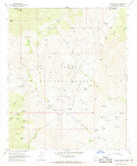
~ Bloody Basin AZ topo map, 1:24000 scale, 7.5 X 7.5 Minute, Historical, 1967, updated 1968
Bloody Basin, Arizona, USGS topographic map dated 1967.
Includes geographic coordinates (latitude and longitude). This topographic map is suitable for hiking, camping, and exploring, or framing it as a wall map.
Printed on-demand using high resolution imagery, on heavy weight and acid free paper, or alternatively on a variety of synthetic materials.
Topos available on paper, Waterproof, Poly, or Tyvek. Usually shipping rolled, unless combined with other folded maps in one order.
- Product Number: USGS-5550274
- Free digital map download (high-resolution, GeoPDF): Bloody Basin, Arizona (file size: 10 MB)
- Map Size: please refer to the dimensions of the GeoPDF map above
- Weight (paper map): ca. 55 grams
- Map Type: POD USGS Topographic Map
- Map Series: HTMC
- Map Verison: Historical
- Cell ID: 4410
- Scan ID: 310513
- Imprint Year: 1968
- Woodland Tint: Yes
- Aerial Photo Year: 1965
- Field Check Year: 1967
- Datum: NAD27
- Map Projection: Polyconic
- Map published by United States Geological Survey
- Map Language: English
- Scanner Resolution: 600 dpi
- Map Cell Name: Bloody Basin
- Grid size: 7.5 X 7.5 Minute
- Date on map: 1967
- Map Scale: 1:24000
- Geographical region: Arizona, United States
Neighboring Maps:
All neighboring USGS topo maps are available for sale online at a variety of scales.
Spatial coverage:
Topo map Bloody Basin, Arizona, covers the geographical area associated the following places:
- Bloody Basin - Hummingbird Spring - Mud Spring Creek - Best Tank - Red Rock Spring - Hidden Tank - Trail Tank - Rusty Tank - Soda Springs Creek - Sahuaro Tank - Picnic Spring - LX Bar Ranch - Roadside Tank - Bottle Tank - Four Corners Tank - Soda Spring Number One - Quail Spring - Tony Tank - Surprise Spring - Tear Spring - Monroe Canyon Windmill - Cottonwood Spring - North Pass Tank Number One - Tangle Creek Administrative Site - TT Ranch - Metate Spring - Coyote Spring - Lizard Spring - Tangle Peak Tank - Corral Spring - LX Spring - Cement Tank - Mustang Hills - Mustang Tank - Dugan Tank - North Pasture Spring - North Pass Tank Number Two - Rusty Tank Number Two - Hutch Gulch Creek - Cockleburr Spring - Middle Red Creek - Mule Spring - Frog Spring - Double Tank - Soda Spring Number Two - Monroe Canyon - Beal Tank - Doe Tank - Mud Spring - Yellow Jacket Canyon - Hutch Gulch - Zig Zag Spring - Big Buck Tank - Round Corral - Ruin Point Tank - Dugan Ranch - North Pass Spring - Marble Mine - Turtle Tank - Dugan Rock Tank - Red Creek Spring - Roundtree Canyon - Red Creek Ranch - Rugged Mesa Tank - Brushy Creek - Juniper Tank - Horseshoe Tank - Danes Dam - Corral Spring - White Rock Spring - Pistol Saddle Tank - Trap Canyon - Tangle Creek Cabin - Turret Peak - North Red Creek - Tumbleweed Spring - Yellow Jacket Tank Number One - South Fork Mud Spring Creek - Javelina Tank - Peet Spring - Thicket Spring - Dog Spring - Nigh Trap Tank - Lower Red Creek Spring - Willow Spring
- Map Area ID: AREA34.2534.125-111.875-111.75
- Northwest corner Lat/Long code: USGSNW34.25-111.875
- Northeast corner Lat/Long code: USGSNE34.25-111.75
- Southwest corner Lat/Long code: USGSSW34.125-111.875
- Southeast corner Lat/Long code: USGSSE34.125-111.75
- Northern map edge Latitude: 34.25
- Southern map edge Latitude: 34.125
- Western map edge Longitude: -111.875
- Eastern map edge Longitude: -111.75


