
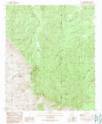
~ Big Lue Mountains AZ topo map, 1:24000 scale, 7.5 X 7.5 Minute, Historical, 1989, updated 1989
Big Lue Mountains, Arizona, USGS topographic map dated 1989.
Includes geographic coordinates (latitude and longitude). This topographic map is suitable for hiking, camping, and exploring, or framing it as a wall map.
Printed on-demand using high resolution imagery, on heavy weight and acid free paper, or alternatively on a variety of synthetic materials.
Topos available on paper, Waterproof, Poly, or Tyvek. Usually shipping rolled, unless combined with other folded maps in one order.
- Product Number: USGS-5550166
- Free digital map download (high-resolution, GeoPDF): Big Lue Mountains, Arizona (file size: 16 MB)
- Map Size: please refer to the dimensions of the GeoPDF map above
- Weight (paper map): ca. 55 grams
- Map Type: POD USGS Topographic Map
- Map Series: HTMC
- Map Verison: Historical
- Cell ID: 3767
- Scan ID: 310453
- Imprint Year: 1989
- Woodland Tint: Yes
- Aerial Photo Year: 1984
- Edit Year: 1989
- Field Check Year: 1986
- Datum: NAD27
- Map Projection: Transverse Mercator
- Provisional map: Yes
- Map published by United States Geological Survey
- Map Language: English
- Scanner Resolution: 600 dpi
- Map Cell Name: Big Lue Mountains
- Grid size: 7.5 X 7.5 Minute
- Date on map: 1989
- Map Scale: 1:24000
- Geographical region: Arizona, United States
Neighboring Maps:
All neighboring USGS topo maps are available for sale online at a variety of scales.
Spatial coverage:
Topo map Big Lue Mountains, Arizona, covers the geographical area associated the following places:
- Yellow Bull Spring - Tennessee Tank - Pothole Canyon - Red Spring - Coal Creek Campground - Sixshooter Tank - White Mule Creek - Seep Spring Canyon - Pinyon Tank - Maggett Spring - Holdup Ground Tank - Coal Creek Tank - Bear Tank - Bens Tank - The Junipers - Jeffers Tank - Juniper Corral - Big Lue Ranch - Big Lue Spring - Line Tank - Stockton Gap - Blackjack Campground - Base Tanks - Big Lue Spring - Maverick Trailhead - Fence Line Tank - Ball Tank - Park Tank - Dunigan Spring - Sweet Spring - Lost Spring - Phillips Tank - Tennessee Tank - Willis Spring - Black Jack Spring - Deer Canyon - Maverick Basin - Rock Bottom Tank - Big Lue Corral - Pig Pen Spring - Blackjack Tank - Mexican Spring - Corral Tank - Black Jack Group Campground - Old Collett Tank - Bee Tree Spring - Maverick Hill Tank - Winchester Tank - Maverick Hill - Pinyon Tank - West Coal Creek Corral - Mexican Spring - Yellow Bull Spring - Bee Tree Spring - Lower Bee Tree Spring - Maverick Tank - Pothole Tank - McMullen Peak - Sluff Spring - White Mule Windmill - Needles Eye - Old Collett Tank - North Fork Tennessee Creek - Winchester Tank - Palace Peak - Partnership Tank - Juniper Corral - Jeffers Tank - Pothole Tank - White Mule Windmill - Bear Track Tank - Cottonwood Spring - West Coal Creek Well - Cold Spring - Upper Hells Hole Spring - Partnership Tank - Big Lue Mountains - Neck Tank - Rock Bottom Tank
- Map Area ID: AREA33.12533-109.125-109
- Northwest corner Lat/Long code: USGSNW33.125-109.125
- Northeast corner Lat/Long code: USGSNE33.125-109
- Southwest corner Lat/Long code: USGSSW33-109.125
- Southeast corner Lat/Long code: USGSSE33-109
- Northern map edge Latitude: 33.125
- Southern map edge Latitude: 33
- Western map edge Longitude: -109.125
- Eastern map edge Longitude: -109


