
~ Big Lake North AZ topo map, 1:24000 scale, 7.5 X 7.5 Minute, Historical, 1991, updated 1991
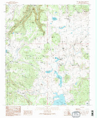
Big Lake North, Arizona, USGS topographic map dated 1991.
Includes geographic coordinates (latitude and longitude). This topographic map is suitable for hiking, camping, and exploring, or framing it as a wall map.
Printed on-demand using high resolution imagery, on heavy weight and acid free paper, or alternatively on a variety of synthetic materials.
Topos available on paper, Waterproof, Poly, or Tyvek. Usually shipping rolled, unless combined with other folded maps in one order.
- Product Number: USGS-5550156
- Free digital map download (high-resolution, GeoPDF): Big Lake North, Arizona (file size: 12 MB)
- Map Size: please refer to the dimensions of the GeoPDF map above
- Weight (paper map): ca. 55 grams
- Map Type: POD USGS Topographic Map
- Map Series: HTMC
- Map Verison: Historical
- Cell ID: 3760
- Scan ID: 310448
- Imprint Year: 1991
- Woodland Tint: Yes
- Aerial Photo Year: 1984
- Edit Year: 1991
- Field Check Year: 1985
- Datum: NAD27
- Map Projection: Transverse Mercator
- Map published by United States Geological Survey
- Map Language: English
- Scanner Resolution: 600 dpi
- Map Cell Name: Big Lake North
- Grid size: 7.5 X 7.5 Minute
- Date on map: 1991
- Map Scale: 1:24000
- Geographical region: Arizona, United States
Neighboring Maps:
All neighboring USGS topo maps are available for sale online at a variety of scales.
Spatial coverage:
Topo map Big Lake North, Arizona, covers the geographical area associated the following places:
- North Hog Wallow Tank - Wahl Knoll - Burro Creek Spring Number 1 - Seventy-Three Tank - Horse Corral Tank - Egg Tank - Half Tank - Crossbar Tank - Phelps Spring - Pothole Tank - Corner Tank - Dipping Vat Reservoir - Burro Creek - Mandan Tank - Phelps Ranch - Dump Spring - Lee Valley Reservoir Boat Launch - Bill Riley Tank - Phelps Fire Station - North Fork Black River - Big Lake - Pool Corral Dam - Spence Spring - Lee Valley Dam - Drumstick Tank - Ant Tank - Fir Pit Tank - Rock Spring - Pool Knoll Tank - Lower Tank - Buckshot Spring - SU Spring - Riley Canyon Tank - Spruce Spring - Voigt Ranch - Lake Tank - BC Tank - Convicted Spring - Tommie Spring - Seven Springs - Big Lake Recreation Area - South Crescent Lake Boat Launch - South Hog Wallow Tank - Udall 12 Spring - Big Lake Railroad Cove Boat Launch - Pool Corral Lake Tank - 409 Road Well - Rudd Knoll Tank Number 5 - Winn Sink - Spruce Spring - Deep Pit Tank - Trap Pit - River Number One Dam - Double Spring - Crescent Lake - SU Knolls Spring - Crescent Lake Spring - Phelps Forest Service Facility - Winn Campground - Alleged Spring - Riley Tank - Upper Tank - Little Spring - Mike Tank - Cherokee Tank - Hog Wallow Lake - East Fork Baldy Trail Ninetyfive - S U Knolls - Burro Creek Spring - Voigt Pit Tank Number Six - Pool Corral Lake - Crescent Lake Dam - South Fork Tank - 72 Tank - Corral Tank - Brookchar Campground - Track Tank - Government Spring Forest Camp - Crescent Lake Dam Boat Launch - Sugar Spring - Hog Wallow Dam - Dipping Vat Spring - Seventy-Four Tank - Clear Cut Spring - Wing Marsh - Head of Black River Springs - Bull Pasture Tank - Definite Spring - South Fork Tank - Buckshot Spring - Head of South Fork Spring - BC Tank Number 1 - Cienega Spring - Road Tank - Burro Mountain Weir - Burro Mountain - Basin Lake - Crescent Lake West Side Boat Launch - Draw Tank - Round Cienega Spring
- Map Area ID: AREA3433.875-109.5-109.375
- Northwest corner Lat/Long code: USGSNW34-109.5
- Northeast corner Lat/Long code: USGSNE34-109.375
- Southwest corner Lat/Long code: USGSSW33.875-109.5
- Southeast corner Lat/Long code: USGSSE33.875-109.375
- Northern map edge Latitude: 34
- Southern map edge Latitude: 33.875
- Western map edge Longitude: -109.5
- Eastern map edge Longitude: -109.375


