
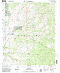
~ Bee Canyon AZ topo map, 1:24000 scale, 7.5 X 7.5 Minute, Historical, 1997, updated 2000
Bee Canyon, Arizona, USGS topographic map dated 1997.
Includes geographic coordinates (latitude and longitude). This topographic map is suitable for hiking, camping, and exploring, or framing it as a wall map.
Printed on-demand using high resolution imagery, on heavy weight and acid free paper, or alternatively on a variety of synthetic materials.
Topos available on paper, Waterproof, Poly, or Tyvek. Usually shipping rolled, unless combined with other folded maps in one order.
- Product Number: USGS-5550110
- Free digital map download (high-resolution, GeoPDF): Bee Canyon, Arizona (file size: 13 MB)
- Map Size: please refer to the dimensions of the GeoPDF map above
- Weight (paper map): ca. 55 grams
- Map Type: POD USGS Topographic Map
- Map Series: HTMC
- Map Verison: Historical
- Cell ID: 3020
- Scan ID: 310425
- Imprint Year: 2000
- Woodland Tint: Yes
- Aerial Photo Year: 1992
- Datum: NAD27
- Map Projection: Transverse Mercator
- Map published by United States Geological Survey
- Map published by United States Forest Service
- Map Language: English
- Scanner Resolution: 600 dpi
- Map Cell Name: Bee Canyon
- Grid size: 7.5 X 7.5 Minute
- Date on map: 1997
- Map Scale: 1:24000
- Geographical region: Arizona, United States
Neighboring Maps:
All neighboring USGS topo maps are available for sale online at a variety of scales.
Spatial coverage:
Topo map Bee Canyon, Arizona, covers the geographical area associated the following places:
- Black Mountain Tank - Baseline Tank - Bear Canyon - Upper Big Dry Tank - Oak Tank - Moore Ranch - Sheep Wash Tank - Smith Canyon - Cottonwood Spring Number 3 - Sheep Wash - Black Tank - Line Tank - Bear Tank - Open Draw Tank - Sunflower Mesa Tank - Seep Tank - Summit Corral - Gibson Tank - Mesa Tank - Woolaroc - Split Tank - Sunflower Mesa - Bear Canyon Well - Rough Ridge Tank - Bee Springs Tank - N O Bar Ranch - Willow Creek - Moore Tank - Forks Tank - Butte Tank - Deer Tank - Grass Tank - Coyote Tank - Sheep Springs - Double Circle Ranch - Secondary Tank - Glenn Tank - Bee Canyon - Simmons Spring - Hicks Tank - Greenwade Ranch - Baseline Tank Number 2 - Cottonwood Spring Number 2 - Bluff Tank - Eagle Elementary School - Middle Prong Tank - Old Tank - Corner Tank - Mud Springs Canyon - Cottonwood Corral - Moore Tank - Big Dry Canyon - Water Canyon - Hicks Ranch - Pine Spring Tank - Hidden Tank - Division Tank - Lee Tank - New Tank - N O Bar Mesa Tank - Bee Canyon Tank - CC Tank - Edwards Tank - Summit Spring - ST Well - Bar F Canyon - Sandstone Tank - North Corral Creek - Cottonwood Tank - Horse Springs - Butte Tank Number Two - Black Mountain - Pine Creek Tank
- Map Area ID: AREA33.37533.25-109.5-109.375
- Northwest corner Lat/Long code: USGSNW33.375-109.5
- Northeast corner Lat/Long code: USGSNE33.375-109.375
- Southwest corner Lat/Long code: USGSSW33.25-109.5
- Southeast corner Lat/Long code: USGSSE33.25-109.375
- Northern map edge Latitude: 33.375
- Southern map edge Latitude: 33.25
- Western map edge Longitude: -109.5
- Eastern map edge Longitude: -109.375


