
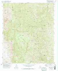
~ Bassett Peak AZ topo map, 1:24000 scale, 7.5 X 7.5 Minute, Historical, 1972, updated 1975
Bassett Peak, Arizona, USGS topographic map dated 1972.
Includes geographic coordinates (latitude and longitude). This topographic map is suitable for hiking, camping, and exploring, or framing it as a wall map.
Printed on-demand using high resolution imagery, on heavy weight and acid free paper, or alternatively on a variety of synthetic materials.
Topos available on paper, Waterproof, Poly, or Tyvek. Usually shipping rolled, unless combined with other folded maps in one order.
- Product Number: USGS-5550058
- Free digital map download (high-resolution, GeoPDF): Bassett Peak, Arizona (file size: 17 MB)
- Map Size: please refer to the dimensions of the GeoPDF map above
- Weight (paper map): ca. 55 grams
- Map Type: POD USGS Topographic Map
- Map Series: HTMC
- Map Verison: Historical
- Cell ID: 2582
- Scan ID: 310397
- Imprint Year: 1975
- Woodland Tint: Yes
- Aerial Photo Year: 1971
- Field Check Year: 1972
- Datum: NAD27
- Map Projection: Universal Transverse Mercator
- Map published by United States Geological Survey
- Map Language: English
- Scanner Resolution: 600 dpi
- Map Cell Name: Bassett Peak
- Grid size: 7.5 X 7.5 Minute
- Date on map: 1972
- Map Scale: 1:24000
- Geographical region: Arizona, United States
Neighboring Maps:
All neighboring USGS topo maps are available for sale online at a variety of scales.
Spatial coverage:
Topo map Bassett Peak, Arizona, covers the geographical area associated the following places:
- Broken Horn Canyon - Rattlesnake Spring - East Divide Two hundred eighty seven Trail - Kielberg Peak - Mitchell Spring - North Fork Douglas Canyon - Bassett Peak - Cedar Spring - Cement Dam Tank - Muleshoe Canyon - West Divide Two Hundred Eighty-nine - Grassy Ridge Tank - Hooker Cabin - Upper Ash Spring - Sunset Canyon - High Creek Spring - Lower Ash Spring - Grassy Ridge Spring - Black Eagle Canyon - Negro Canyon - Mott Spring - Gold Gulch - Knothe Spring - Hooker Tank - Grassy Peak - Cedar Flat - Browning Cement Dam Tank - Maple Spring - Kielberg Tank - Sunset Peak - Holdout Spring - South Negro Canyon - Upper Flat Spring - Alamo Spring - Browning Dam - Sol Rhea Spring - Echols Spring - Long Tom Mine - Powers Mine - Negro Spring - Cottonwood Mountain Trail Sixty six - Galiuro Wilderness
- Map Area ID: AREA32.62532.5-110.375-110.25
- Northwest corner Lat/Long code: USGSNW32.625-110.375
- Northeast corner Lat/Long code: USGSNE32.625-110.25
- Southwest corner Lat/Long code: USGSSW32.5-110.375
- Southeast corner Lat/Long code: USGSSE32.5-110.25
- Northern map edge Latitude: 32.625
- Southern map edge Latitude: 32.5
- Western map edge Longitude: -110.375
- Eastern map edge Longitude: -110.25


