
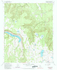
~ Ashurst Lake AZ topo map, 1:24000 scale, 7.5 X 7.5 Minute, Historical, 1962, updated 1984
Ashurst Lake, Arizona, USGS topographic map dated 1962.
Includes geographic coordinates (latitude and longitude). This topographic map is suitable for hiking, camping, and exploring, or framing it as a wall map.
Printed on-demand using high resolution imagery, on heavy weight and acid free paper, or alternatively on a variety of synthetic materials.
Topos available on paper, Waterproof, Poly, or Tyvek. Usually shipping rolled, unless combined with other folded maps in one order.
- Product Number: USGS-5549940
- Free digital map download (high-resolution, GeoPDF): Ashurst Lake, Arizona (file size: 12 MB)
- Map Size: please refer to the dimensions of the GeoPDF map above
- Weight (paper map): ca. 55 grams
- Map Type: POD USGS Topographic Map
- Map Series: HTMC
- Map Verison: Historical
- Cell ID: 1697
- Scan ID: 310333
- Imprint Year: 1984
- Woodland Tint: Yes
- Visual Version Number: 1
- Photo Inspection Year: 1980
- Photo Revision Year: 1974
- Aerial Photo Year: 1974
- Field Check Year: 1962
- Datum: NAD27
- Map Projection: Polyconic
- Map published by United States Geological Survey
- Map Language: English
- Scanner Resolution: 600 dpi
- Map Cell Name: Ashurst Lake
- Grid size: 7.5 X 7.5 Minute
- Date on map: 1962
- Map Scale: 1:24000
- Geographical region: Arizona, United States
Neighboring Maps:
All neighboring USGS topo maps are available for sale online at a variety of scales.
Spatial coverage:
Topo map Ashurst Lake, Arizona, covers the geographical area associated the following places:
- Ashurst Run - Forked Pine Picnic Area - Pickett Lake - Snag Tank - Youngs Spring - Horse Lake - Pine Grove Campground - Otteson Tank - Red Tank - Juniper Tank - Upper Lake Mary - Adams Tank - Ashurst Lake Dam - Ashurst Tank - Lake View Campground - Ashurst Lake - Horse Tank - Forked Pine Campground - Deep Lake Tank - Elk Spring - Youngs Tank - Mormon Canyon Tank One - Coconino Lake - Youngs Lake - Railroad Trick Tank - Rye Tank - Potato Lake Tank - Canyon Tank - Pine Grove Camp and Picnic Grounds - Coconino Dam - Johns Tank - Mormon Canyon Tank Two - Breezy Number One Tank - Deep Lake - Als Lake - Dunn Tank - Ashurst Lake Boat Launch - Cabin Tank - Indian Lake Tank - Ashurst Spring - Youngs Spring Tank - Railroad Tank - Ashurst Lake Campground - Post Lake - Newman Canyon - Foster Tank - Indian Lake - Anderson Mesa - Antelope Tank - Indian Lake Tank - Flagstaff Division - Potato Lake
- Map Area ID: AREA35.12535-111.5-111.375
- Northwest corner Lat/Long code: USGSNW35.125-111.5
- Northeast corner Lat/Long code: USGSNE35.125-111.375
- Southwest corner Lat/Long code: USGSSW35-111.5
- Southeast corner Lat/Long code: USGSSE35-111.375
- Northern map edge Latitude: 35.125
- Southern map edge Latitude: 35
- Western map edge Longitude: -111.5
- Eastern map edge Longitude: -111.375


