
~ Apache Maid Mtn AZ topo map, 1:24000 scale, 7.5 X 7.5 Minute, Historical, 1965, updated 1973
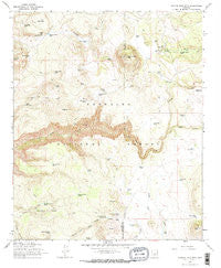
Apache Maid Mtn, Arizona, USGS topographic map dated 1965.
Includes geographic coordinates (latitude and longitude). This topographic map is suitable for hiking, camping, and exploring, or framing it as a wall map.
Printed on-demand using high resolution imagery, on heavy weight and acid free paper, or alternatively on a variety of synthetic materials.
Topos available on paper, Waterproof, Poly, or Tyvek. Usually shipping rolled, unless combined with other folded maps in one order.
- Product Number: USGS-5549856
- Free digital map download (high-resolution, GeoPDF): Apache Maid Mtn, Arizona (file size: 12 MB)
- Map Size: please refer to the dimensions of the GeoPDF map above
- Weight (paper map): ca. 55 grams
- Map Type: POD USGS Topographic Map
- Map Series: HTMC
- Map Verison: Historical
- Cell ID: 1242
- Scan ID: 310292
- Imprint Year: 1973
- Woodland Tint: Yes
- Aerial Photo Year: 1962
- Field Check Year: 1965
- Datum: NAD27
- Map Projection: Polyconic
- Map published by United States Geological Survey
- Map Language: English
- Scanner Resolution: 600 dpi
- Map Cell Name: Apache Maid Mountain
- Grid size: 7.5 X 7.5 Minute
- Date on map: 1965
- Map Scale: 1:24000
- Geographical region: Arizona, United States
Neighboring Maps:
All neighboring USGS topo maps are available for sale online at a variety of scales.
Spatial coverage:
Topo map Apache Maid Mtn, Arizona, covers the geographical area associated the following places:
- Hog Hill - Utopia Tank - Cuter Place Tank - Bruce Place Tank - Road Tank - Burnt Basin Tank - Cuter Tank - Apache Maid Cabin - Mullican Ranch - Harris Tank - Big Hill - Mullican Place Tank - Trail Tank - Lookout Point Tank - T-Bar Ranch - Tin Roof Tank - Anniversary Tank - Roundup Basin Tank - Jacks Canyon - Rocky Gulch - Knob Tank - Fivemile Pass Tank - Big Hill Tank - Campbell Draw Tank - New Tank - Horse Knoll Tank - V D Tank - North Rim Tank - Division Tank - Round Mountain Tank - Four Wall Tank - Brady Tank - Wet Beaver Wilderness - T-bar Tank Number One - Waldroup Tank - T-bar Tank Number Two - Cove Tank - Tinny Tank - Little Hog Hill Tank - Mullican Tank Number One - Wier Number Six - Horse Knoll - Table Mountain Tank - Slope Tank - Weir Number Eleven - Brady Canyon - Apache Maid Mountain - Fivemile Pass - Wier Number Five - Fritz Tank - Pine Ridge Tank - Waldroup Place Tank - Fivemile Pass Tank Number Two - Fivemile Pass Tank Number One - Oak Hill - Table Mountain - Apache Maid Trail - Sues Tank - T-Bar Tank - Apache Maid Ranger Station - Roundup Basin - Table Mountain Tank - Rim Tank - Cuter Tank - Sues Tank - Mullican Tank - Three Wall Tank - Maid Tank
- Map Area ID: AREA34.7534.625-111.625-111.5
- Northwest corner Lat/Long code: USGSNW34.75-111.625
- Northeast corner Lat/Long code: USGSNE34.75-111.5
- Southwest corner Lat/Long code: USGSSW34.625-111.625
- Southeast corner Lat/Long code: USGSSE34.625-111.5
- Northern map edge Latitude: 34.75
- Southern map edge Latitude: 34.625
- Western map edge Longitude: -111.625
- Eastern map edge Longitude: -111.5


