
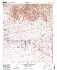
~ Apache Junction AZ topo map, 1:24000 scale, 7.5 X 7.5 Minute, Historical, 1956, updated 1983
Apache Junction, Arizona, USGS topographic map dated 1956.
Includes geographic coordinates (latitude and longitude). This topographic map is suitable for hiking, camping, and exploring, or framing it as a wall map.
Printed on-demand using high resolution imagery, on heavy weight and acid free paper, or alternatively on a variety of synthetic materials.
Topos available on paper, Waterproof, Poly, or Tyvek. Usually shipping rolled, unless combined with other folded maps in one order.
- Product Number: USGS-5549846
- Free digital map download (high-resolution, GeoPDF): Apache Junction, Arizona (file size: 16 MB)
- Map Size: please refer to the dimensions of the GeoPDF map above
- Weight (paper map): ca. 55 grams
- Map Type: POD USGS Topographic Map
- Map Series: HTMC
- Map Verison: Historical
- Cell ID: 1241
- Scan ID: 310287
- Imprint Year: 1983
- Woodland Tint: Yes
- Visual Version Number: 1
- Photo Revision Year: 1982
- Aerial Photo Year: 1978
- Edit Year: 1982
- Field Check Year: 1956
- Datum: NAD27
- Map Projection: Polyconic
- Map published by United States Geological Survey
- Map published by United States Army Corps of Engineers
- Map published by United States Army
- Map Language: English
- Scanner Resolution: 600 dpi
- Map Cell Name: Apache Junction
- Grid size: 7.5 X 7.5 Minute
- Date on map: 1956
- Map Scale: 1:24000
- Geographical region: Arizona, United States
Neighboring Maps:
All neighboring USGS topo maps are available for sale online at a variety of scales.
Spatial coverage:
Topo map Apache Junction, Arizona, covers the geographical area associated the following places:
- La Casa Blanca Mobile Home Park - Silverado Estates Mobile Home Park - Sunset Mesa Mobile Home Park - Acacia Villa Mobile Home Park - The Pueblo Mobile Home Park - Meridian Manufactured Home Park - Boardwalk Estates Mobile Home Park - Palm Springs - Superstition Mobile Ranch - Apache East Estates Mobile Home Park - Lamplighter Mobile Village - Apache Skies Mobile Home Park - Blue Star Mobile Home Park - Windsong Mobile Home Park - Dolce Vita at Superstition Mountain Mobile Home Park - Palo Verde Hills Mobile Park - Twin Acres Family Mobile Park - Apache Mountain Shadows Trailer Ranch - Klahanne Mobile Home Park - Apache Junction Mobile Homes Park - Sundowner Mobile Home Park - Weavers Needle Travel Trailer Park - Palmas Del Sol East Mobile Home Park - Rancho Mirage Mobile Home Park - Sierra Del Saguaro Mobile Home Park - Quail Run Mobile Home Park - Desert Village Mobile Home Park - Superstition Shadows Mobile Home Park - Apache Gardens Mobile Home Park - Patio Gardens Mobile Home Park - Baywood Mobile Park - Chaparral Mobile Ranch - Trails West Mobile Home Park - Lost Dutchman Mobile Home Park - Oasis Junction Mobile Home Park - El Dorado Mobile Estates Resort - Husky Hollow Mobile Home Park - Palms Mobile Home Park - Sun Valley Mobile Home Park - Round - Up Mobile Home Park - Mountain Vista Mobile Home Park - Coral Sands Mobile Estates - Danas Trailer Ranch - Raindance Mobile Home Park - Valley Palms Mobile Home Park - Apache Acres Trailer Park - Sierra Leone Mobile Park - Denali Park Estates Mobile Home Park - Shady Rest Mobile Home Park - Desert Harbor Mobile Home Park - Cherokee Mobile Village - Desert Park Mobile Home Park - Superstition Mobile Village - Bonita Vista Mobile Home Park - Valley Palms Mobile Home Park - Meridiancheri Mobile Home Park - Pacific Mobile Manor - White Sands Estate Mobile Home Park - Western Acres Mobile Park - La Casa Trail Mobile Villa - Roadhaven Recreational Vehicle Resort - Rancho Reata Mobile Home Park - Cactus Gardens Mobile Home Park - Apache Junction
- Map Area ID: AREA33.533.375-111.625-111.5
- Northwest corner Lat/Long code: USGSNW33.5-111.625
- Northeast corner Lat/Long code: USGSNE33.5-111.5
- Southwest corner Lat/Long code: USGSSW33.375-111.625
- Southeast corner Lat/Long code: USGSSE33.375-111.5
- Northern map edge Latitude: 33.5
- Southern map edge Latitude: 33.375
- Western map edge Longitude: -111.625
- Eastern map edge Longitude: -111.5


