
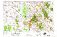
~ Tucson AZ topo map, 1:250000 scale, 1 X 2 Degree, Historical, 1956, updated 1967
Tucson, Arizona, USGS topographic map dated 1956.
Includes geographic coordinates (latitude and longitude). This topographic map is suitable for hiking, camping, and exploring, or framing it as a wall map.
Printed on-demand using high resolution imagery, on heavy weight and acid free paper, or alternatively on a variety of synthetic materials.
Topos available on paper, Waterproof, Poly, or Tyvek. Usually shipping rolled, unless combined with other folded maps in one order.
- Product Number: USGS-5549652
- Free digital map download (high-resolution, GeoPDF): Tucson, Arizona (file size: 19 MB)
- Map Size: please refer to the dimensions of the GeoPDF map above
- Weight (paper map): ca. 55 grams
- Map Type: POD USGS Topographic Map
- Map Series: HTMC
- Map Verison: Historical
- Cell ID: 69061
- Scan ID: 315609
- Imprint Year: 1967
- Woodland Tint: Yes
- Aerial Photo Year: 1956
- Edit Year: 1962
- Datum: Unstated
- Map Projection: Transverse Mercator
- Map published by United States Army Corps of Engineers
- Map published by United States Army
- Map Language: English
- Scanner Resolution: 600 dpi
- Map Cell Name: Tucson
- Grid size: 1 X 2 Degree
- Date on map: 1956
- Map Scale: 1:250000
- Geographical region: Arizona, United States
Neighboring Maps:
All neighboring USGS topo maps are available for sale online at a variety of scales.
Spatial coverage:
Topo map Tucson, Arizona, covers the geographical area associated the following places:
- Plaza Del Sol Mobile Home Resort - Queens Well - Mountain Vista Mobile Home Park - Vista Del Rey Mobile Home Park - Falcon Ridge Mobile Home Park - Soldier Camp - Terra Vista Estates Mobile Home Park - Skyline Bel Aire Estates - Wickchoupai - Town and Country Mobile Home Park - Branding Iron Mobile Home Park - Jackrabbit House - Casa Dulce Mobile Home Park - Vaiva Vo - Harrison Hills Mobile Home Park - Johnson - Esmond - Las Casitas Mobile Home Park - Catalina Vista Mobile Home Community - Vandenberg Village - Shannon Trees Mobile Home Park - Emery Park - Picacho - Orchard Valley Mobile Home Park - Loma Linda - Whitetail - Brentwood Mobile Home Park - BeLaire Mobile Home Park - Nolic - Las Palmes Mobile Home Park - Oro Valley - Triple K Mobile Home Park - Country Club Mobile Home Park - Bermuda Gardens Trailer Park - Hoi Oidak - Casa Verde Estates Mobile Home Park - Oak Wells - Cottonwood Manor Mobile Home Park - Sil Nakya - Hookers Hot Springs - Summerhaven - Redwood Mobile Home Park - Sunny Lane Mobile Home Park - Columbia Mobile Home Park - Cactus Forest - Arizonian Mobile Home Park - Kingston Knolls Terrace - Villa Capri Mobile Home Park Phase I - Desert Classic Mobile Home Park - Vista Del Norte Mobile Estates - Laguna - Roadrunner Mobile Home Park - Village Mobile Home Park - Cortaro - Cardinal Lane Mobile Home Park - San Pedro - Gardner Estates - Oracle Foothills Estates - Corner Windmill - Vail - Comobabi - Far Horizons Mobile Home Park - Ko Vaya - Desert Pueblo Mobile Home Park - Summit - Highlands Mobile Home Community - Foothills Mobile Home Park - Mission View Club Estates Mobile Home Park - Via Verde West Mobile Home Park - Colonial Del Sol Mobile Home Park - Five Star Mobile Home Park - Swan Lake Estates Mobile Home Park - Golden Park for Mobile Homes - Schuchk - Diamond Grove Estates Mobile Home Park - El Camino Mobile Park - Silent Wheels Ranchomes - Desert Breeze Mobile Home Park - Catalina - Randolph - Arizola - Coolidge - Indian Ridge Estates - Dudleyville - Mountain View - Stanfield - Black Mountain Estates - Far Horizons East Mobile Home Park - San Manuel - Buffalo Mobile Home Park - Oracle Junction - Foothills West Resort Mobile Home Park - Eloy - Cielo Vista Mobile Home Park - Desert Vista Mobile Home Park - Verde Plaza Mobile Home Park - Haivana Nakya - Double R Ranch Mobile Home Park - Mesa Ridge Mobile Home Park - Old Tucson
- Map Area ID: AREA3332-112-110
- Northwest corner Lat/Long code: USGSNW33-112
- Northeast corner Lat/Long code: USGSNE33-110
- Southwest corner Lat/Long code: USGSSW32-112
- Southeast corner Lat/Long code: USGSSE32-110
- Northern map edge Latitude: 33
- Southern map edge Latitude: 32
- Western map edge Longitude: -112
- Eastern map edge Longitude: -110


