
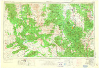
~ Prescott AZ topo map, 1:250000 scale, 1 X 2 Degree, Historical, 1954, updated 1973
Prescott, Arizona, USGS topographic map dated 1954.
Includes geographic coordinates (latitude and longitude). This topographic map is suitable for hiking, camping, and exploring, or framing it as a wall map.
Printed on-demand using high resolution imagery, on heavy weight and acid free paper, or alternatively on a variety of synthetic materials.
Topos available on paper, Waterproof, Poly, or Tyvek. Usually shipping rolled, unless combined with other folded maps in one order.
- Product Number: USGS-5549634
- Free digital map download (high-resolution, GeoPDF): Prescott, Arizona (file size: 15 MB)
- Map Size: please refer to the dimensions of the GeoPDF map above
- Weight (paper map): ca. 55 grams
- Map Type: POD USGS Topographic Map
- Map Series: HTMC
- Map Verison: Historical
- Cell ID: 74966
- Scan ID: 707530
- Imprint Year: 1973
- Woodland Tint: Yes
- Visual Version Number: 2
- Aerial Photo Year: 1954
- Edit Year: 1970
- Datum: Unstated
- Map Projection: Transverse Mercator
- Map published by United States Geological Survey
- Map Language: English
- Scanner Resolution: 508 dpi
- Map Cell Name: Prescott
- Grid size: 1 X 2 Degree
- Date on map: 1954
- Map Scale: 1:250000
- Geographical region: Arizona, United States
Neighboring Maps:
All neighboring USGS topo maps are available for sale online at a variety of scales.
Spatial coverage:
Topo map Prescott, Arizona, covers the geographical area associated the following places:
- Pine Haven Mobile Home Park - Country West Mobile Home Park - Dewey - Cordes - Packer - Deering Park Estates - Prescott Gardens Mobile Home Park - Humbug - Goodwin - Tapco - Alamo Crossing (historical) - Clemenceau - Beverly Gardens Trailer Park - Highland Park - Centerville - Fort Whipple - Congress Junction - Tip Top (historical) - Rush Place Windmill - Planet - Sand Mill - Miller Valley - Fort Misery - Paulden - Cordes Lakes - Williamson - Hillside - Wood Trap - Diamond Valley - Constellation - Cottonwood Heights Mobile Home Park - Wikieup - Forbing Park - Wildwood Estates - Willow Spring - Abra - Cleator - Bagdad - Columbia - Arcosanti - Wilhoit - Iron Springs - Del Rio - P and E Junction - Vista Del Sol Mobile Home Park - Sycamore - Dandrea - Glen Oaks - Walker - Rock Springs - Granite Siding - Bear - White Cloud Mobile Home Park - Jerome - McNary Place - Canyon Retreat Mobile Home Park - Drake - Shadow Mountain Mobile Home Park - Walker Place Windmill - Yavapai Hills - Whipple - Skull Valley - Roadrunner Mobile Home Park - Cordes Junction - Flores - Bumble Bee - Kirkland Junction - Wagoner - Tutt - Midway - Peeples Valley - Kirkland - Congress - Briggs - Apron Crossing - Chino Valley - Lampliter Village Mobile Home Park - Dewey-Humboldt - South Fort - Octave - Baldwin Place - Copperopolis - Spring Valley - Mayer - Granite Dells - Mack - Glen Ilah - Crown King - Gillette - Hawkins - Prescott - Cherry - Mint - Groom Creek - Greenwood - Burro John - Humboldt - Paxton Place - Lehman Mill - Iron Springs Manor Mobile Home Park
- Map Area ID: AREA3534-114-112
- Northwest corner Lat/Long code: USGSNW35-114
- Northeast corner Lat/Long code: USGSNE35-112
- Southwest corner Lat/Long code: USGSSW34-114
- Southeast corner Lat/Long code: USGSSE34-112
- Northern map edge Latitude: 35
- Southern map edge Latitude: 34
- Western map edge Longitude: -114
- Eastern map edge Longitude: -112


