
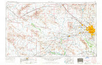
~ Phoenix AZ topo map, 1:250000 scale, 1 X 2 Degree, Historical, 1954, updated 1970
Phoenix, Arizona, USGS topographic map dated 1954.
Includes geographic coordinates (latitude and longitude). This topographic map is suitable for hiking, camping, and exploring, or framing it as a wall map.
Printed on-demand using high resolution imagery, on heavy weight and acid free paper, or alternatively on a variety of synthetic materials.
Topos available on paper, Waterproof, Poly, or Tyvek. Usually shipping rolled, unless combined with other folded maps in one order.
- Product Number: USGS-5549618
- Free digital map download (high-resolution, GeoPDF): Phoenix, Arizona (file size: 16 MB)
- Map Size: please refer to the dimensions of the GeoPDF map above
- Weight (paper map): ca. 55 grams
- Map Type: POD USGS Topographic Map
- Map Series: HTMC
- Map Verison: Historical
- Cell ID: 74961
- Scan ID: 315570
- Imprint Year: 1970
- Woodland Tint: Yes
- Aerial Photo Year: 1953
- Edit Year: 1969
- Field Check Year: 1954
- Datum: Unstated
- Map Projection: Transverse Mercator
- Map published by: Military, Other
- Map Language: English
- Scanner Resolution: 600 dpi
- Map Cell Name: Phoenix
- Grid size: 1 X 2 Degree
- Date on map: 1954
- Map Scale: 1:250000
- Geographical region: Arizona, United States
Neighboring Maps:
All neighboring USGS topo maps are available for sale online at a variety of scales.
Spatial coverage:
Topo map Phoenix, Arizona, covers the geographical area associated the following places:
- Aguila - Michigan Trailer Park - Country Manor Mobile Home Park - Longhaven West - Hassayampa - Western Acres Mobile Home Park - Capri Village - Casa Del Sol Resort West Mobile Home Park - Estrella Valley Mobile Home Park - Perryville - Palo Verde Mobile Home and Recreational Vehicle Park - Tonopah - Lake Biltmore Estates - Suncrest Mobile Home Park II - Val Vista Trailer Park - Village Park - Apollo Mobile Home Park - Sun Trailer Park - San Gabriel - Matthie - Byrds Mobile Home Park - Suncrest Mobile Home Park I - Cotton Center - Palo Verde - Saddlehorn Ranch - Estrella Villa Mobile Home Park - Shamrock Mobile Home Park - Biltmore Gates - Copper Kettle Trailer Villa - Marco Polo Mobile Home Park - Buena Vista Mobile Home Park - Citrus Hills - Lexington Place - Bethany Villa Adult Mobile Home Park - Glendale - West End - Pepper Ridge - Tolleson - Grand Missouri Adult Mobile Home Park - Hidden Acres Mobile Home Park - Lizard - Catalina Village - Paradise City - Marlborough Meadows - Papago - Sunset Village - Mountain View Trailer Court - Southern Acres Mobile Home Park - Villas Plaza - Biltmore Greens III - Fairwood VIII - Arrowhead Ranch - Fox Glen - Heaton - Glen Canyon Trailer Park - McVay - Sun City - Country Hills Mobile Estates - Sacate - Surprise - Harqua - Deer Valley - Moon Valley Mobile Home Estates - Heritage Highlands - DeLuxe Trailer Court - Peacock Village - Montara - Peoria Palms Mobile Home Park - Santa Maria - Rosewood Estates Mobile Home Park - Colony Biltmore IV - Westbrook Village - Crag - Casa Rosa - Desert Wells - Amberwood North - Plaza Trailer Inn - Greentrails - Sundad - Desert Valley Estates - Canyon View - Maryland West Mobile Home Park - Wickenburg - Valley Gardens Trailer Park - Windsor Square - Adobe Mountain Trailer Park - Peoria Polynesian Village - New River - Cashion - Allah - Indian Springs - Roles Inn of America - Cottonwood Ranch - San Miguel - Arbor Manor Mobile Home Park - Maricopa Wells - Estrella - Rose Garden Place - Quail Lane - Pioneer Estates
- Map Area ID: AREA3433-114-112
- Northwest corner Lat/Long code: USGSNW34-114
- Northeast corner Lat/Long code: USGSNE34-112
- Southwest corner Lat/Long code: USGSSW33-114
- Southeast corner Lat/Long code: USGSSE33-112
- Northern map edge Latitude: 34
- Southern map edge Latitude: 33
- Western map edge Longitude: -114
- Eastern map edge Longitude: -112


