
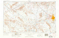
~ Phoenix AZ topo map, 1:250000 scale, 1 X 2 Degree, Historical, 1954, updated 1968
Phoenix, Arizona, USGS topographic map dated 1954.
Includes geographic coordinates (latitude and longitude). This topographic map is suitable for hiking, camping, and exploring, or framing it as a wall map.
Printed on-demand using high resolution imagery, on heavy weight and acid free paper, or alternatively on a variety of synthetic materials.
Topos available on paper, Waterproof, Poly, or Tyvek. Usually shipping rolled, unless combined with other folded maps in one order.
- Product Number: USGS-5549612
- Free digital map download (high-resolution, GeoPDF): Phoenix, Arizona (file size: 16 MB)
- Map Size: please refer to the dimensions of the GeoPDF map above
- Weight (paper map): ca. 55 grams
- Map Type: POD USGS Topographic Map
- Map Series: HTMC
- Map Verison: Historical
- Cell ID: 74961
- Scan ID: 315567
- Imprint Year: 1968
- Edit Year: 1964
- Field Check Year: 1954
- Datum: Unstated
- Map Projection: Transverse Mercator
- Map published by United States Army Corps of Engineers
- Map published by United States Army
- Map Language: English
- Scanner Resolution: 600 dpi
- Map Cell Name: Phoenix
- Grid size: 1 X 2 Degree
- Date on map: 1954
- Map Scale: 1:250000
- Geographical region: Arizona, United States
Neighboring Maps:
All neighboring USGS topo maps are available for sale online at a variety of scales.
Spatial coverage:
Topo map Phoenix, Arizona, covers the geographical area associated the following places:
- Orangewood Village Mobilehome Park - Wigwam Villa Mobile Home Park - The Palms of El Mirage Mobile Home Park - Shadow Hills Mobile Home Park - Blue Palm Mobile Home Park - Arlington - Overland Trail - Catalina Village - Sky Ridge Mobile Homes - Saddle - Estrella Valley Mobile Home Park - Flamingo Mobile Home Resort - Covered Wagon Mobile Home Park - Windsor Square - Rose Garden Mobile Home Resort - La Montana Del Sur Mobile Home Park - Sunset Vista - Trail Inn Lodge - Peoria - Turf Mobile Manor - Westridge Park - Youngtown - Shamrock Mobile Home Park - Komatke - Santa Cruz - Palo Verde - Young America West - Cactus Gardens Mobile Home Park - Maricopa - Stony Mountain Villas - Love - Bonaventure Mobile Home Community - Paradise City - Desert Valley Estates - Belaire Manor Mobile Home Park - Palmaritas - Valley View - Matthie - Citrus Park - Ak-Chin Village - Circle City - Hope - Desert Estates Mobile Home Park - Surprise - Trail-R-Dale Mobile Home Park - Mountain View Trailer Court - Saint Johns Mission - Paradise Valley Mobilhome Park - Peri-Winkle Mobile Home Park - Gladden - Glendale West Mobile Home Park - Country Manor Mobile Home Park - Desert Pines - Welcome Home Mobile Park - Allah - Castle Hot Springs - Vistancia - Royal Palm Travel Trailer and Mobile Home Park - Silver Bell Trailer Park (historical) - Shadow Canyon - Forepaugh - La Fontana Heights - Biltmore Gates - Brandywine - Liberty Mobile Home Park - Roadrunner Mobile Home Park - Bethany Grand Mobile Home Park - Rose Garden Place - Camel - Suncrest Villas East - Country Villa - A and F Trailer Park - Mayflower Terrace - Co-op Village - West End - Utting - Braemar VII - Maryvale Terrace - Cashion - Phoenix West Mobile Home Park - The Pointe - Eighteen Bells Mobile Home Park - Squaw Peak Terrace - Tonopah - Hyder - Lone Butte Ranch - Palo Verde Mobile Home and Recreational Vehicle Park - Goodyear - Val Vista Trailer Park - Mountain Gate Mobile Home Park - Amberwood North - Chris-Town Travel Trailer and Mobile Home Park - Cataline Village Mobile Home Park - Santa Maria - El Mirage - Bristol Square - Sunray Manor - Sleepy Hollow Trailer Village - Willows West - McMicken
- Map Area ID: AREA3433-114-112
- Northwest corner Lat/Long code: USGSNW34-114
- Northeast corner Lat/Long code: USGSNE34-112
- Southwest corner Lat/Long code: USGSSW33-114
- Southeast corner Lat/Long code: USGSSE33-112
- Northern map edge Latitude: 34
- Southern map edge Latitude: 33
- Western map edge Longitude: -114
- Eastern map edge Longitude: -112


