
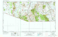
~ Nogales AZ topo map, 1:250000 scale, 1 X 2 Degree, Historical, 1956, updated 1978
Nogales, Arizona, USGS topographic map dated 1956.
Includes geographic coordinates (latitude and longitude). This topographic map is suitable for hiking, camping, and exploring, or framing it as a wall map.
Printed on-demand using high resolution imagery, on heavy weight and acid free paper, or alternatively on a variety of synthetic materials.
Topos available on paper, Waterproof, Poly, or Tyvek. Usually shipping rolled, unless combined with other folded maps in one order.
- Product Number: USGS-5549606
- Free digital map download (high-resolution, GeoPDF): Nogales, Arizona (file size: 14 MB)
- Map Size: please refer to the dimensions of the GeoPDF map above
- Weight (paper map): ca. 55 grams
- Map Type: POD USGS Topographic Map
- Map Series: HTMC
- Map Verison: Historical
- Cell ID: 72241
- Scan ID: 315562
- Imprint Year: 1978
- Woodland Tint: Yes
- Aerial Photo Year: 1955
- Edit Year: 1969
- Field Check Year: 1956
- Datum: Unstated
- Map Projection: Transverse Mercator
- Map published by United States Geological Survey
- Map Language: English
- Scanner Resolution: 600 dpi
- Map Cell Name: Nogales
- Grid size: 1 X 2 Degree
- Date on map: 1956
- Map Scale: 1:250000
- Geographical region: Arizona, United States
Neighboring Maps:
All neighboring USGS topo maps are available for sale online at a variety of scales.
Spatial coverage:
Topo map Nogales, Arizona, covers the geographical area associated the following places:
- Rosemont Camp - Cowlic - Campstone - Chiawuli Tak - Arivaca Junction - Trench Camp - Uhs Kug - Ruby - Hacienda Los Encino - Sasabe - Green Valley - Sells - Kino Springs - Utevak - San Pedro Mobile Home Park - West Pershing Plaza - Contention - Boquillas - Kahachi Miliuk - Rio Rico - Los Arboles Mobile Home Park - Washington Camp - Gatewood Housing - Sahuarita - Charleston (historical) - Corona de Tucson - Pimaco Two - Sunnyside - Carmen - Lochiel - Choulic - Helvetia - Huachuca City - Sierra Vista - Hereford - Coronado Village - Topawa - Hashan Chuchg - Black Bear Spring - Puertocito - Chamiso - Fenner - Ak Chut Vaya - Cavalay Park - Oro Blanco - Miles Manor - Patagonia - Buenos Aires - Los Arcos Mobile Home Park - De Anza Village - Elgin - Sahuarita Heights Mobile Home Park - Madera Canyon - Las Guijas - Whetstone - Saint David - Sierra Grande Mobile Home Park - Sapano Vaya - East Sahuarita - Vopolo Havoka - Nogales - Continental - Ramsey - Stark - Kom Kug - Canelo - Air Haven Mobile Home Estates - Pantano - Partridge (historical) - Pomerene - Arivaca - Duquesne - Benson Junction - San Xavier - Pitoikam - Ali Chukson - Miracle Valley - Green Valley Pueblo Estates - Sotos Crossing (historical) - Whetstone - Sierra Vista Estates - Benson - Apache Mobile Park - Escalante Crossing - Rosemont Junction - Sahuarita Heights - Nicksville - San Agustin - Newfield - Fry - Sonoita - San Miguel - Sandwash Mill - Village Meadows - Twin Buttes - Amado - Agua Linda - Tubac - Chiuli Shaik - Haivan Vaya
- Map Area ID: AREA3231-112-110
- Northwest corner Lat/Long code: USGSNW32-112
- Northeast corner Lat/Long code: USGSNE32-110
- Southwest corner Lat/Long code: USGSSW31-112
- Southeast corner Lat/Long code: USGSSE31-110
- Northern map edge Latitude: 32
- Southern map edge Latitude: 31
- Western map edge Longitude: -112
- Eastern map edge Longitude: -110


