
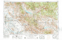
~ Mesa AZ topo map, 1:250000 scale, 1 X 2 Degree, Historical, 1954, updated 1979
Mesa, Arizona, USGS topographic map dated 1954.
Includes geographic coordinates (latitude and longitude). This topographic map is suitable for hiking, camping, and exploring, or framing it as a wall map.
Printed on-demand using high resolution imagery, on heavy weight and acid free paper, or alternatively on a variety of synthetic materials.
Topos available on paper, Waterproof, Poly, or Tyvek. Usually shipping rolled, unless combined with other folded maps in one order.
- Product Number: USGS-5549596
- Free digital map download (high-resolution, GeoPDF): Mesa, Arizona (file size: 25 MB)
- Map Size: please refer to the dimensions of the GeoPDF map above
- Weight (paper map): ca. 55 grams
- Map Type: POD USGS Topographic Map
- Map Series: HTMC
- Map Verison: Historical
- Cell ID: 68907
- Scan ID: 315550
- Imprint Year: 1979
- Woodland Tint: Yes
- Visual Version Number: 1
- Aerial Photo Year: 1978
- Edit Year: 1978
- Field Check Year: 1954
- Datum: Unstated
- Map Projection: Transverse Mercator
- Map published by United States Geological Survey
- Map published by: Military, Other
- Map Language: English
- Scanner Resolution: 600 dpi
- Map Cell Name: Mesa
- Grid size: 1 X 2 Degree
- Date on map: 1954
- Map Scale: 1:250000
- Geographical region: Arizona, United States
Neighboring Maps:
All neighboring USGS topo maps are available for sale online at a variety of scales.
Spatial coverage:
Topo map Mesa, Arizona, covers the geographical area associated the following places:
- Pinnacle Peak Heights - Suncrest Villas Mesa - Hayden - Bapchule - Palo Verde Hills Mobile Park - Holiday Village Mobile Home Park - Las Alegres - Sunview - Citrus Grove Trailer Court - Higley - Camp Creek - Colonial Coronita - Smelter Town - La Casa Trail Mobile Villa - Stotonic - Karmella Mobile Home Park - Ocotillo - Tremaine - Papago Peaks Village - Tempe Cascade - Venture Out Recreational Vehicle Resort - Paradise Village North II - Roosevelt Resort - Pacific Mobile Manor - Apache Wells - Windsong Mobile Home Park - Snaketown - West Mesa Trailer Court - Casas del Campo Mobile Home Park - Grapevine - Raintree Luxury Homes - Las Palmas Mobile Home Park - Silver Spur Ranch Mobile Home Park - Price - Rancho Del Escondido - Estates La Colina - McCormick Ranch - Amberwood II - Greenbrier East - The Lakes - Paradise Valley Miranda - Tempe Travel Trailer Villa - Desert Vista Recreational Vehicle Resort - Chandler Heights - Shady Ranch Trailer Lodge - Queen Creek - The Haciendas - Troy - Kearny Mobile Home Park - Geronimo - Fish Creek (historical) - Western Acres Mobile Park - Gainey Ranch - Elmwood Trailer Park - San Carlos - Pinnacle Peak Country Club Estates - Sonora Town - Palmas Del Sol East Mobile Home Park - Palms Mobile Home Park - Country Cousins Mobile Mecca - Mountain View Mobile Home Park - Royal Palm Village Mobile Home Park - Hacienda de Valencia - Burch - Sundial Mobile Park - Lariat Tra-Tel Trailer Court - Valley Palms Mobile Home Park - Raindance Mobile Home Park - Mountain Vista Mobile Home Park - Breezeway Trailer Park - Desert Village Mobile Home Park - Sun Valley Mobile Home Park - Kelvin - Parkview Mesa - Redwood Gardens Mobile Home Park - Stonegate Crossing - Dreamland Villa - Cactus Villa - Marlborough Park - Alma Gardens - Heritage Court - Superior - Warner Park - Meadowvale - Shiloh Canyon - Paradise Peak West Mobile Home Park - Los Maderas - San Tan Valley - Hawaiian Village Mobile Home Park - Bridgeport - Suntrails - Cimarron - Serape - Rancho de Arboleda - Sacaton Flats - Sunshine Acres - Rancho Tempe Family and Adult Mobile Home Park - Shady Rest Mobile Home Park - Palm Springs - Fountain East
- Map Area ID: AREA3433-112-110
- Northwest corner Lat/Long code: USGSNW34-112
- Northeast corner Lat/Long code: USGSNE34-110
- Southwest corner Lat/Long code: USGSSW33-112
- Southeast corner Lat/Long code: USGSSE33-110
- Northern map edge Latitude: 34
- Southern map edge Latitude: 33
- Western map edge Longitude: -112
- Eastern map edge Longitude: -110


