
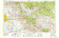
~ Mesa AZ topo map, 1:250000 scale, 1 X 2 Degree, Historical, 1954, updated 1979
Mesa, Arizona, USGS topographic map dated 1954.
Includes geographic coordinates (latitude and longitude). This topographic map is suitable for hiking, camping, and exploring, or framing it as a wall map.
Printed on-demand using high resolution imagery, on heavy weight and acid free paper, or alternatively on a variety of synthetic materials.
Topos available on paper, Waterproof, Poly, or Tyvek. Usually shipping rolled, unless combined with other folded maps in one order.
- Product Number: USGS-5549594
- Free digital map download (high-resolution, GeoPDF): Mesa, Arizona (file size: 25 MB)
- Map Size: please refer to the dimensions of the GeoPDF map above
- Weight (paper map): ca. 55 grams
- Map Type: POD USGS Topographic Map
- Map Series: HTMC
- Map Verison: Historical
- Cell ID: 68907
- Scan ID: 315549
- Imprint Year: 1979
- Woodland Tint: Yes
- Visual Version Number: 2
- Aerial Photo Year: 1978
- Edit Year: 1978
- Field Check Year: 1954
- Datum: Unstated
- Map Projection: Transverse Mercator
- Map published by United States Geological Survey
- Map Language: English
- Scanner Resolution: 600 dpi
- Map Cell Name: Mesa
- Grid size: 1 X 2 Degree
- Date on map: 1954
- Map Scale: 1:250000
- Geographical region: Arizona, United States
Neighboring Maps:
All neighboring USGS topo maps are available for sale online at a variety of scales.
Spatial coverage:
Topo map Mesa, Arizona, covers the geographical area associated the following places:
- Palmas del Sol - Sunny Crest Mobile Home Park - Scottsdale Ranch - Cypress Estates - Stotonic - Lost Dutchman Mobile Home Park - Hohokam Village - Cambridge Heights - Rancho Del Escondido - Brighton Place - University Mobile Home Park - New Horizons - Silver Spur Ranch Mobile Home Park - Ellison Place (historical) - Patio Gardens Mobile Home Park - Los Tesoros - Kingsgate - Hightown - Shady Ranch Trailer Lodge - Roadrunner Lake Resort Mobile Home Park - Pinnacle Peak Village - Village Fairways - Conquistador Mobile Home Park - Lazona Trailer Court - Montecito Mobile Home Estates - Alhambra Mobile Home Park - Mesa Village Mobile Home Park - Casa Blanca - Claypool - Green Acres Trailer Court - Husky Hollow Mobile Home Park - Fort McDowell - August Hills Mobile Home Park - Prado del Sol - Velda Rose Gardens - Rancho Reata Mobile Home Park - Redwood Gardens Mobile Home Park - Dove Valley Ranch - Cedar Creek Crossing - Radium - Pepperwood - Sun Lakes - Cinco Soles - Kearny Mobile Home Park - The Wells Mobile Home Park - Horse Mesa - Greenhaven Mobile Park - Hayden - Sunridge IV - Windsor Mobile Home Park - Grapevine - McClintock Manor - Tovrea - Las Palmas Mobile Home Park - Pinnacle Peak Heights V-VI - Parkside - Fountain Hills - Denali Park Estates Mobile Home Park - Reynolds Trailer Court - Kon Tiki Mobile Home Park - Mesa Gardens Mobile Home Park - Summer Mesa - Germann - Heatherbrook - Paradise Valley - Quail Place - Country Club Village Mobile Home Park - Florence - Suntrails - New Hope Trailer Park - Natches - Troy - Citrus Gardens - Rancho de Arboleda - Scottsdale Mobile Home Park - Roosevelt - Roosevelt Lake Gardens East - Raindance Mobile Home Park - Cactus Villa - Summer Place Trails - Warner Park - Shadow Ridge II - Nortons Corner - Mesa Grande Trailer Ranch - Country Trace - Hyde Park Lodge - Paradise Valley Miranda - Kelvin - Colonial Coronita - Bridgeport - Mountain Vista Mobile Home Park - Clearview Hills - Cedar Ridge - Desert Wind - The Home Place - Sunshine Acres - Hyde Park - Brentwood West Mobile Home Park - West Mesa Trailer Court - Riviera Mobile Home Park
- Map Area ID: AREA3433-112-110
- Northwest corner Lat/Long code: USGSNW34-112
- Northeast corner Lat/Long code: USGSNE34-110
- Southwest corner Lat/Long code: USGSSW33-112
- Southeast corner Lat/Long code: USGSSE33-110
- Northern map edge Latitude: 34
- Southern map edge Latitude: 33
- Western map edge Longitude: -112
- Eastern map edge Longitude: -110


