
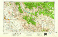
~ Mesa AZ topo map, 1:250000 scale, 1 X 2 Degree, Historical, 1960, updated 1960
Mesa, Arizona, USGS topographic map dated 1960.
Includes geographic coordinates (latitude and longitude). This topographic map is suitable for hiking, camping, and exploring, or framing it as a wall map.
Printed on-demand using high resolution imagery, on heavy weight and acid free paper, or alternatively on a variety of synthetic materials.
Topos available on paper, Waterproof, Poly, or Tyvek. Usually shipping rolled, unless combined with other folded maps in one order.
- Product Number: USGS-5549586
- Free digital map download (high-resolution, GeoPDF): Mesa, Arizona (file size: 23 MB)
- Map Size: please refer to the dimensions of the GeoPDF map above
- Weight (paper map): ca. 55 grams
- Map Type: POD USGS Topographic Map
- Map Series: HTMC
- Map Verison: Historical
- Cell ID: 68907
- Scan ID: 315545
- Imprint Year: 1960
- Woodland Tint: Yes
- Field Check Year: 1954
- Datum: Unstated
- Map Projection: Transverse Mercator
- Map published by United States Geological Survey
- Map published by United States Army Corps of Engineers
- Map published by United States Army
- Map Language: English
- Scanner Resolution: 600 dpi
- Map Cell Name: Mesa
- Grid size: 1 X 2 Degree
- Date on map: 1960
- Map Scale: 1:250000
- Geographical region: Arizona, United States
Neighboring Maps:
All neighboring USGS topo maps are available for sale online at a variety of scales.
Spatial coverage:
Topo map Mesa, Arizona, covers the geographical area associated the following places:
- Chrysotile - Pinnacle Peak Estates III - Apache Skies Mobile Home Park - Cactus Villa - Oasis Junction Mobile Home Park - McClintock Manor - Black River Crossing - Fort McDowell - DC Ranch - Continental Village - Karmella Mobile Home Park - Cactus Wren Mobile Park - Quail Run Mobile Home Park - The Pointe at South Mountain - Kon Tiki Mobile Home Park - Sandalwood - Roadhaven Recreational Vehicle Resort - Wheel Inn Ranch - Quail Valley - Bell Acres Mobile Home Park - Los Maderas - Country Cousins Mobile Mecca - Esplanada - Nortons Corner - Sunset Trail Ranch Mobile Home Park - Sunridge IV - Silverado Estates Mobile Home Park - Wishing Well Trailer Park - Snaketown - Brentwood Southern Mobile Home Park - Apache Gardens Mobile Home Park - Pinnacle Peak Estates I - Greenfield Estates - Reata Pass - Kyrene - Little Acres - Brentwood West Mobile Home Park - Homestead - Marlborough Mesa - Miami - Paradise Village North II - Camelback Estates IV - Radium - Superior - Apache Junction - West Chandler - Casa Blanca - Lemontree - Cherokee Mobile Village - Pony Acres Mobile Home Park - Starlite Trailer Park - Rancho Tempe Family and Adult Mobile Home Park - Gold Camp - Rancho Rio Vista Mobile Home Park - Dobson Ranch - Casa Linda - Mirador - MonDak Mobile Home Park - Desert Wind II - Horse Mesa - Mesa Travelodge Mobile Home Park - McDowell Mountain Ranch - Sierra Estates Mobile Home Park - Kensington - Pinnacle Paradise - Wagon Wheel Mobile Ranch - Santan - Government Hill - El Dorado Mobile Estates Resort - Midland City - Tiburon - Gainey Ranch - Mesa - Haciendas del Lago - M and M Mobile Village - Sagewood - Trovia - Summer Place Trails - Admiral Trailer Park - Greenway Park V - Pleasant Valley Mobile Home Park - Meridiancheri Mobile Home Park - Pueblo Sereno Mobile Home Park - Hamilton Corner - Desert Villas - El Mirage - Rambler Mobile Park - Valley Mobile Homes Estate - Kearny - Crestview - Eastway Mobile Home Park - Blue Star Mobile Home Park - Shadow Ridge II - Estados de La Mancha II - Mesa Village Mobile Home Park - Firebrand Ranch - Sweetwater Ranch - Fountain East - Dixileta Verde - Palo Verde Mobile Manor
- Map Area ID: AREA3433-112-110
- Northwest corner Lat/Long code: USGSNW34-112
- Northeast corner Lat/Long code: USGSNE34-110
- Southwest corner Lat/Long code: USGSSW33-112
- Southeast corner Lat/Long code: USGSSE33-110
- Northern map edge Latitude: 34
- Southern map edge Latitude: 33
- Western map edge Longitude: -112
- Eastern map edge Longitude: -110


