
~ Marble Canyon AZ topo map, 1:250000 scale, 1 X 2 Degree, Historical, 1956, updated 1973
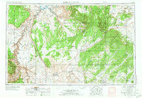
Marble Canyon, Arizona, USGS topographic map dated 1956.
Includes geographic coordinates (latitude and longitude). This topographic map is suitable for hiking, camping, and exploring, or framing it as a wall map.
Printed on-demand using high resolution imagery, on heavy weight and acid free paper, or alternatively on a variety of synthetic materials.
Topos available on paper, Waterproof, Poly, or Tyvek. Usually shipping rolled, unless combined with other folded maps in one order.
- Product Number: USGS-5549580
- Free digital map download (high-resolution, GeoPDF): Marble Canyon, Arizona (file size: 19 MB)
- Map Size: please refer to the dimensions of the GeoPDF map above
- Weight (paper map): ca. 55 grams
- Map Type: POD USGS Topographic Map
- Map Series: HTMC
- Map Verison: Historical
- Cell ID: 74978
- Scan ID: 315537
- Imprint Year: 1973
- Woodland Tint: Yes
- Visual Version Number: 2
- Aerial Photo Year: 1955
- Edit Year: 1970
- Field Check Year: 1956
- Datum: Unstated
- Map Projection: Transverse Mercator
- Map published by United States Geological Survey
- Map Language: English
- Scanner Resolution: 600 dpi
- Map Cell Name: Marble Canyon
- Grid size: 1 X 2 Degree
- Date on map: 1956
- Map Scale: 1:250000
- Geographical region: Arizona, United States
Neighboring Maps:
All neighboring USGS topo maps are available for sale online at a variety of scales.
Spatial coverage:
Topo map Marble Canyon, Arizona, covers the geographical area associated the following places:
- Pinon - Babetts Trailer Court - Navajo Mountain Mission - Navajo Gospel Mission - Chilchinbito - Moenave - Kaibito - Willow Springs - Vista Encantada - Cow Springs - Page - Rare Metals - Wahweap - Bitter Springs - Marble Canyon - Red Lake - Shonto - Chapman's Mobile Home Resort - Tonalea - Tuba City - Chair Crossing - Kayenta - Betatakin Overlook - Page Lake Powell Mobile Home Village - Rim View Trailer Village - Moenkopi - Baby Rocks - Hidden Springs Mission - Hard Rocks - Tsegi
- Map Area ID: AREA3736-112-110
- Northwest corner Lat/Long code: USGSNW37-112
- Northeast corner Lat/Long code: USGSNE37-110
- Southwest corner Lat/Long code: USGSSW36-112
- Southeast corner Lat/Long code: USGSSE36-110
- Northern map edge Latitude: 37
- Southern map edge Latitude: 36
- Western map edge Longitude: -112
- Eastern map edge Longitude: -110


