
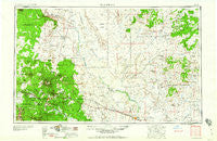
~ Flagstaff AZ topo map, 1:250000 scale, 1 X 2 Degree, Historical, 1960, updated 1960
Flagstaff, Arizona, USGS topographic map dated 1960.
Includes geographic coordinates (latitude and longitude). This topographic map is suitable for hiking, camping, and exploring, or framing it as a wall map.
Printed on-demand using high resolution imagery, on heavy weight and acid free paper, or alternatively on a variety of synthetic materials.
Topos available on paper, Waterproof, Poly, or Tyvek. Usually shipping rolled, unless combined with other folded maps in one order.
- Product Number: USGS-5549522
- Free digital map download (high-resolution, GeoPDF): Flagstaff, Arizona (file size: 16 MB)
- Map Size: please refer to the dimensions of the GeoPDF map above
- Weight (paper map): ca. 55 grams
- Map Type: POD USGS Topographic Map
- Map Series: HTMC
- Map Verison: Historical
- Cell ID: 74970
- Scan ID: 315485
- Imprint Year: 1960
- Woodland Tint: Yes
- Visual Version Number: 1
- Aerial Photo Year: 1954
- Field Check Year: 1954
- Datum: Unstated
- Map Projection: Transverse Mercator
- Map published by United States Army Corps of Engineers
- Map published by United States Army
- Map Language: English
- Scanner Resolution: 600 dpi
- Map Cell Name: Flagstaff
- Grid size: 1 X 2 Degree
- Date on map: 1960
- Map Scale: 1:250000
- Geographical region: Arizona, United States
Neighboring Maps:
All neighboring USGS topo maps are available for sale online at a variety of scales.
Spatial coverage:
Topo map Flagstaff, Arizona, covers the geographical area associated the following places:
- Sunset Crossing (historical) - Canyon Diablo - Sunshine - Coal Mine Mesa - Wolf Crossing - Wildwood Hills Mobile Home Park - Mumurva - Tees Toh - Hidden Hollow Mobile Home Park - Kachina Village - Pink Arrow - Bushman Acres - Black Falls Crossing - Jo Don Mobile Home Park - Cosnino - Kykotsmovi Village - Dennison - Pumpkin Center - Castle Butte - Gray Mountain - Brigham City (historical) - Wheel Inn Mobile Home Park - Na Ah Tee - Pivahn-hon-kya-pi - Sundown Mobile Home Park - Keams Canyon - Flagstaff - Sichomovi - Tiis Holoni - Bidahochi - Silver Saddle Mobile Home Park - Tolchico - East Flagstaff - Fort Tuthill - First Mesa - Darling - Winslow - West Winslow - Riordan - Nesuftanga - Tolani Lake - Parks - Kokopnyama - Angell - Wepo Village - Sand Springs - Second Mesa - Bellemont - Shongopovi - Cameo Mobile Home Park - Huk Ovi - Sipaulovi - Hotevilla - Aponi-vi - Low Mountain - Colony Mobile Estates - Mahtson-pi - Meteor City - Dilkon - Leupp - Polacca - Seba Dalkai - Winona - Mountainaire - Elden Pueblo - Cogdill Center - Old Leupp - Shungopavi - Cameron - Oraibi - Sunrise - Smoke Signal - White Cone - Walpi - Canyon View Mobile Home Park - Chakpahu - Two Guns - Hotevilla-Bacavi - Toreva - Leupp Corner - LeChee - Indian Wells - Winslow West - Arrowhead Village Mobile Home Park - Rimmy Jims - Hano - Cedar Springs - Mishongnovi - Kykotsmovi - Moqui - Old Shongopavi (historical) - Kawaika-A - Maine - The Elms Mobile Home Park - Jeddito - Bacavi - Sunset City (historical)
- Map Area ID: AREA3635-112-110
- Northwest corner Lat/Long code: USGSNW36-112
- Northeast corner Lat/Long code: USGSNE36-110
- Southwest corner Lat/Long code: USGSSW35-112
- Southeast corner Lat/Long code: USGSSE35-110
- Northern map edge Latitude: 36
- Southern map edge Latitude: 35
- Western map edge Longitude: -112
- Eastern map edge Longitude: -110


