
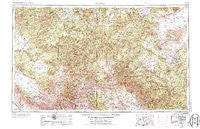
~ Clifton AZ topo map, 1:250000 scale, 1 X 2 Degree, Historical, 1954, updated 1974
Clifton, Arizona, USGS topographic map dated 1954.
Includes geographic coordinates (latitude and longitude). This topographic map is suitable for hiking, camping, and exploring, or framing it as a wall map.
Printed on-demand using high resolution imagery, on heavy weight and acid free paper, or alternatively on a variety of synthetic materials.
Topos available on paper, Waterproof, Poly, or Tyvek. Usually shipping rolled, unless combined with other folded maps in one order.
- Product Number: USGS-5549500
- Free digital map download (high-resolution, GeoPDF): Clifton, Arizona (file size: 26 MB)
- Map Size: please refer to the dimensions of the GeoPDF map above
- Weight (paper map): ca. 55 grams
- Map Type: POD USGS Topographic Map
- Map Series: HTMC
- Map Verison: Historical
- Cell ID: 68720
- Scan ID: 315455
- Imprint Year: 1974
- Woodland Tint: Yes
- Visual Version Number: 2
- Photo Revision Year: 1971
- Aerial Photo Year: 1968
- Edit Year: 1971
- Field Check Year: 1954
- Datum: Unstated
- Map Projection: Transverse Mercator
- Map published by United States Geological Survey
- Map published by: Military, Other
- Map Language: English
- Scanner Resolution: 600 dpi
- Map Cell Name: Clifton
- Grid size: 1 X 2 Degree
- Date on map: 1954
- Map Scale: 1:250000
- Geographical region: Arizona, United States
Neighboring Maps:
All neighboring USGS topo maps are available for sale online at a variety of scales.
Spatial coverage:
Topo map Clifton, Arizona, covers the geographical area associated the following places:
- Whispering Pines - Apache Creek - Charlie Moore Place - Troweek - Crosby Crossing - Boneyard - Nutrioso - Hawley Lake - Sevenmile - Rancho Grande Estates - Spur Lake - Wilcox Peak - Old Horse Springs - Luna - Clifton - Stargo - Strayhorse - Fort Apache - Reserve - Carlton Vista - Spur Cross - Metcalf (historical) - New Horse Springs - Cruzville - Fullerton (historical) - Old Waterman Place - Blue - Fort Thomas - Buckhorn - Blue Vista - Cooney - Claremont - Glenwood - Whiteriver - Three Forks - Point of Pines - Morenci - San Francisco Plaza - Mogollon - Alma - Rastus Place - Sprucedale - Alpine - Aragon - Mule Creek - Lower San Francisco Plaza - Plantsite - Cleaveland - East Plantsite - Ruyle Place - Aspen Mountain - Feaster - Granville - Kinney Junction - Old Campbell Place - Potato Patch - Maverick - Harden Cienega - Hannagan Meadow - Gribble Place - Gila Hot Springs - Pleasanton - East Fork
- Map Area ID: AREA3433-110-108
- Northwest corner Lat/Long code: USGSNW34-110
- Northeast corner Lat/Long code: USGSNE34-108
- Southwest corner Lat/Long code: USGSSW33-110
- Southeast corner Lat/Long code: USGSSE33-108
- Northern map edge Latitude: 34
- Southern map edge Latitude: 33
- Western map edge Longitude: -110
- Eastern map edge Longitude: -108


