
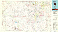
~ Winslow AZ topo map, 1:100000 scale, 30 X 60 Minute, Historical, 1982, updated 1983
Winslow, Arizona, USGS topographic map dated 1982.
Includes geographic coordinates (latitude and longitude). This topographic map is suitable for hiking, camping, and exploring, or framing it as a wall map.
Printed on-demand using high resolution imagery, on heavy weight and acid free paper, or alternatively on a variety of synthetic materials.
Topos available on paper, Waterproof, Poly, or Tyvek. Usually shipping rolled, unless combined with other folded maps in one order.
- Product Number: USGS-5549288
- Free digital map download (high-resolution, GeoPDF): Winslow, Arizona (file size: 16 MB)
- Map Size: please refer to the dimensions of the GeoPDF map above
- Weight (paper map): ca. 55 grams
- Map Type: POD USGS Topographic Map
- Map Series: HTMC
- Map Verison: Historical
- Cell ID: 68608
- Scan ID: 705284
- Imprint Year: 1983
- Woodland Tint: Yes
- Visual Version Number: 2
- Aerial Photo Year: 1979
- Edit Year: 1982
- Datum: NAD27
- Map Projection: Universal Transverse Mercator
- Map published by United States Geological Survey
- Map Language: English
- Scanner Resolution: 508 dpi
- Map Cell Name: Winslow
- Grid size: 30 X 60 Minute
- Date on map: 1982
- Map Scale: 1:100000
- Geographical region: Arizona, United States
Neighboring Maps:
All neighboring USGS topo maps are available for sale online at a variety of scales.
Spatial coverage:
Topo map Winslow, Arizona, covers the geographical area associated the following places:
- Dennison - Sundown Mobile Home Park - West Winslow - Sunset Crossing (historical) - Winslow West - Cedar Springs - Winslow - Old Leupp - LeChee - Dilkon - Sunset City (historical) - Castle Butte - Na Ah Tee - Bushman Acres - Brigham City (historical) - Meteor City - Tolani Lake - Seba Dalkai - Sunrise - Moqui - Leupp Corner - Indian Wells - Tees Toh - Bidahochi
- Map Area ID: AREA35.535-111-110
- Northwest corner Lat/Long code: USGSNW35.5-111
- Northeast corner Lat/Long code: USGSNE35.5-110
- Southwest corner Lat/Long code: USGSSW35-111
- Southeast corner Lat/Long code: USGSSE35-110
- Northern map edge Latitude: 35.5
- Southern map edge Latitude: 35
- Western map edge Longitude: -111
- Eastern map edge Longitude: -110


