
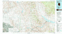
~ Theodore Roosevelt Lake AZ topo map, 1:100000 scale, 30 X 60 Minute, Historical, 1994, updated 1995
Theodore Roosevelt Lake, Arizona, USGS topographic map dated 1994.
Includes geographic coordinates (latitude and longitude). This topographic map is suitable for hiking, camping, and exploring, or framing it as a wall map.
Printed on-demand using high resolution imagery, on heavy weight and acid free paper, or alternatively on a variety of synthetic materials.
Topos available on paper, Waterproof, Poly, or Tyvek. Usually shipping rolled, unless combined with other folded maps in one order.
- Product Number: USGS-5549250
- Free digital map download (high-resolution, GeoPDF): Theodore Roosevelt Lake, Arizona (file size: 32 MB)
- Map Size: please refer to the dimensions of the GeoPDF map above
- Weight (paper map): ca. 55 grams
- Map Type: POD USGS Topographic Map
- Map Series: HTMC
- Map Verison: Historical
- Cell ID: 72201
- Scan ID: 315310
- Imprint Year: 1995
- Woodland Tint: Yes
- Visual Version Number: 1
- Aerial Photo Year: 1975
- Edit Year: 1994
- Datum: NAD27
- Map Projection: Universal Transverse Mercator
- Map published by United States Geological Survey
- Map Language: English
- Scanner Resolution: 600 dpi
- Map Cell Name: Theodore Roosevelt Lake
- Grid size: 30 X 60 Minute
- Date on map: 1994
- Map Scale: 1:100000
- Geographical region: Arizona, United States
Neighboring Maps:
All neighboring USGS topo maps are available for sale online at a variety of scales.
Spatial coverage:
Topo map Theodore Roosevelt Lake, Arizona, covers the geographical area associated the following places:
- Punkin Center - Desert Highlands - Mirador - Riverside Acres - Scottsdale - Rio Verde Estates - Kensington - Cinco Soles - Currys Corner - Estados de La Mancha II - Woodleaf - Greenway Park V - Carefree - Cactus Villa - Chimney Hill - Desert Wind - Roosevelt Lake Gardens East - Montclair Terrace - Shiloh Canyon - Santo Tomas - Heritage North Ranch - Heritage Court - Horse Mesa - Troon - Dove Valley Ranch - Sun Valley Mobile Home Park - Taliesin West - Happy Valley Ranch - Mission Monterey - Fish Creek (historical) - Pinnacle Peak Estates III - Heritage Terrace - Haciendas del Lago - Pinnacle Paradise - Pinnacle Peak Estates I - Santiago - Sweetwater Garden - Continental Village - Camelback Estates IV - Las Villas - Orangetree Estates - El Paseo - Rancho Santa Fe - Casa Rica - Pinnacle Peak Heights V-VI - Camp Creek - Tonto Hills Subdivision - Fort McDowell - Fountain Hills - The Covey - Pinnacle Peak Heights IV - Quail Valley - Pinnacle Peak Shadows - Fountain View - Pinnacle Peak Village - Sandalwood - Sunflower - Windemere - Shadow Ridge II - Windsong - Gainey Ranch - Rio Verde - Lakeview Trailer Park - Bell Acres Mobile Home Park - Country Trace - Reata Pass - Sunset Ridge I - Village Fairways - Links Point - McDowell Mountain Ranch - Paradise Village North II - Sincuidados - Pinnacle Peak Estates II - Pinnacle Peak Country Club Estates - Cobblestone Square - Vista del Cerro - Paradise Valley - Roosevelt Lake Estates - Desert Highlands - Dixileta Verde - Country Horizons - Greenbrier East - Rancho Del Escondido - Buenavante - Roosevelt Lake Gardens West - Scottsdale Ranch - Desert Ridge - Paradise Peak West Mobile Home Park - Trovia - Ensenada del Oro - Carefree Foothills - Roosevelt - Cave Creek - Government Hill - Tonto Basin - Desert Wind II - Sweetwater Ranch - Basking Ridge - Andalusia - Woodleaf II
- Map Area ID: AREA3433.5-112-111
- Northwest corner Lat/Long code: USGSNW34-112
- Northeast corner Lat/Long code: USGSNE34-111
- Southwest corner Lat/Long code: USGSSW33.5-112
- Southeast corner Lat/Long code: USGSSE33.5-111
- Northern map edge Latitude: 34
- Southern map edge Latitude: 33.5
- Western map edge Longitude: -112
- Eastern map edge Longitude: -111


