
~ Sells AZ topo map, 1:100000 scale, 30 X 60 Minute, Historical, 1994, updated 1994
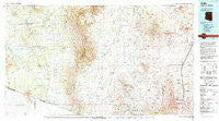
Sells, Arizona, USGS topographic map dated 1994.
Includes geographic coordinates (latitude and longitude). This topographic map is suitable for hiking, camping, and exploring, or framing it as a wall map.
Printed on-demand using high resolution imagery, on heavy weight and acid free paper, or alternatively on a variety of synthetic materials.
Topos available on paper, Waterproof, Poly, or Tyvek. Usually shipping rolled, unless combined with other folded maps in one order.
- Product Number: USGS-5549230
- Free digital map download (high-resolution, GeoPDF): Sells, Arizona (file size: 28 MB)
- Map Size: please refer to the dimensions of the GeoPDF map above
- Weight (paper map): ca. 55 grams
- Map Type: POD USGS Topographic Map
- Map Series: HTMC
- Map Verison: Historical
- Cell ID: 72195
- Scan ID: 315301
- Imprint Year: 1994
- Woodland Tint: Yes
- Aerial Photo Year: 1992
- Edit Year: 1994
- Datum: NAD27
- Map Projection: Universal Transverse Mercator
- Map published by United States Geological Survey
- Map Language: English
- Scanner Resolution: 600 dpi
- Map Cell Name: Sells
- Grid size: 30 X 60 Minute
- Date on map: 1994
- Map Scale: 1:100000
- Geographical region: Arizona, United States
Neighboring Maps:
All neighboring USGS topo maps are available for sale online at a variety of scales.
Spatial coverage:
Topo map Sells, Arizona, covers the geographical area associated the following places:
- Gu Chuapo - Kom Kug - Chiawuli Tak - Amado - Chukson - Arivaca - Chutum Vaya - Las Guijas - Puertocito - Tubac - Kahachi Miliuk - Vopolo Havoka - Arivaca Junction - San Miguel - Otero - Diamond Bell Ranch - San Xavier - Cowlic - Artesa - Topawa - San Agustin - Sells - Uhs Kug - Sotos Crossing (historical) - Newfield - Haivan Vaya - Ak Chut Vaya - Ali Molina - South Komelik - Twin Buttes - Tumacacori - Agua Linda - Kuit Vaya - Vamori - Hashan Chuchg - Ali Chukson - Buenos Aires - Chiuli Shaik - Secundino - Utevak - Choulic - Sapano Vaya - Carmen - Pitoikam
- Map Area ID: AREA3231.5-112-111
- Northwest corner Lat/Long code: USGSNW32-112
- Northeast corner Lat/Long code: USGSNE32-111
- Southwest corner Lat/Long code: USGSSW31.5-112
- Southeast corner Lat/Long code: USGSSE31.5-111
- Northern map edge Latitude: 32
- Southern map edge Latitude: 31.5
- Western map edge Longitude: -112
- Eastern map edge Longitude: -111


