
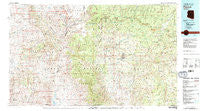
~ Payson AZ topo map, 1:100000 scale, 30 X 60 Minute, Historical, 1981, updated 1981
Payson, Arizona, USGS topographic map dated 1981.
Includes geographic coordinates (latitude and longitude). This topographic map is suitable for hiking, camping, and exploring, or framing it as a wall map.
Printed on-demand using high resolution imagery, on heavy weight and acid free paper, or alternatively on a variety of synthetic materials.
Topos available on paper, Waterproof, Poly, or Tyvek. Usually shipping rolled, unless combined with other folded maps in one order.
- Product Number: USGS-5549186
- Free digital map download (high-resolution, GeoPDF): Payson, Arizona (file size: 33 MB)
- Map Size: please refer to the dimensions of the GeoPDF map above
- Weight (paper map): ca. 55 grams
- Map Type: POD USGS Topographic Map
- Map Series: HTMC
- Map Verison: Historical
- Cell ID: 68129
- Scan ID: 315281
- Imprint Year: 1981
- Woodland Tint: Yes
- Visual Version Number: 1
- Aerial Photo Year: 1978
- Edit Year: 1981
- Datum: NAD27
- Map Projection: Universal Transverse Mercator
- Map published by United States Geological Survey
- Map Language: English
- Scanner Resolution: 600 dpi
- Map Cell Name: Payson
- Grid size: 30 X 60 Minute
- Date on map: 1981
- Map Scale: 1:100000
- Geographical region: Arizona, United States
Neighboring Maps:
All neighboring USGS topo maps are available for sale online at a variety of scales.
Spatial coverage:
Topo map Payson, Arizona, covers the geographical area associated the following places:
- Fort McDonald - Wonder Valley - Sherwood Forest Mobile Home Park - Mountain Meadow - Cedar Mill - Geronimo Estates - Road Junction Windmill - Lancaster - Thompson Draw Summer Homes Unit Two - Ellison Creek Estates - Rye - Lamplighter Mobile Park - Whispering Pines - Mountain Shadows Mobile Trailer Resort - Twin Lakes Mobile Home Park - Tonto Estate - Cedar Grove Mobile Home Park - Diamond Point Summer Homes - Mesa del Caballo - See Canyon Summer Homes - Thompson Draw Summer Homes Unit One - Star Vale Mobile Home Park - Ponderosa Glen Mobile Home Park - Mule Crossing - Payson - Tonto Village - Spurlock - Oxbow Estates - Christopher Creek - Washington Park - Turkey Crossing - Oak Park Mobile Home Park - Coffeepot - Jakes Corner - Star Valley - Freedom Acres - Starview Mobile Home Park - Hunter Creek Ranch - Beaver Valley Estates - Gallups - Deer Creek Village Subdivision - Dugas - Diamond Point Shadows - Gisela - Bonita Creek Estates - Kohls Ranch - Ellison Creek Summer Homes - Strawberry - Pine - Bear Flat - Verde Glen - Arnold Place - Mountain Meadows - La Cienega - Flowing Springs - Campo Bonito - Oxbow Estates Mobile Home Park
- Map Area ID: AREA34.534-112-111
- Northwest corner Lat/Long code: USGSNW34.5-112
- Northeast corner Lat/Long code: USGSNE34.5-111
- Southwest corner Lat/Long code: USGSSW34-112
- Southeast corner Lat/Long code: USGSSE34-111
- Northern map edge Latitude: 34.5
- Southern map edge Latitude: 34
- Western map edge Longitude: -112
- Eastern map edge Longitude: -111


