
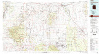
~ Fort Huachuca AZ topo map, 1:100000 scale, 30 X 60 Minute, Historical, 1994, updated 1994
Fort Huachuca, Arizona, USGS topographic map dated 1994.
Includes geographic coordinates (latitude and longitude). This topographic map is suitable for hiking, camping, and exploring, or framing it as a wall map.
Printed on-demand using high resolution imagery, on heavy weight and acid free paper, or alternatively on a variety of synthetic materials.
Topos available on paper, Waterproof, Poly, or Tyvek. Usually shipping rolled, unless combined with other folded maps in one order.
- Product Number: USGS-5549116
- Free digital map download (high-resolution, GeoPDF): Fort Huachuca, Arizona (file size: 25 MB)
- Map Size: please refer to the dimensions of the GeoPDF map above
- Weight (paper map): ca. 55 grams
- Map Type: POD USGS Topographic Map
- Map Series: HTMC
- Map Verison: Historical
- Cell ID: 67532
- Scan ID: 315251
- Imprint Year: 1994
- Woodland Tint: Yes
- Visual Version Number: 1
- Aerial Photo Year: 1991
- Edit Year: 1994
- Datum: NAD27
- Map Projection: Universal Transverse Mercator
- Map published by United States Geological Survey
- Map Language: English
- Scanner Resolution: 600 dpi
- Map Cell Name: Fort Huachuca
- Grid size: 30 X 60 Minute
- Date on map: 1994
- Map Scale: 1:100000
- Geographical region: Arizona, United States
Neighboring Maps:
All neighboring USGS topo maps are available for sale online at a variety of scales.
Spatial coverage:
Topo map Fort Huachuca, Arizona, covers the geographical area associated the following places:
- Lewis Springs - Signal Village - Corona de Tucson - Cavalay Park - Madera Canyon - Elgin - De Anza Village - Helvetia - Fry - Miles Manor - San Pedro Mobile Home Park - Pomerene - Sierra Vista - Sahuarita Heights Mobile Home Park - Sierra Grande Mobile Home Park - Fenner - Duval - Rosemont Camp - Vista View Resort Mobile Home Park - Sahuarita Heights - New Tucson - Apache Mobile Park - Benson - Los Arboles Mobile Home Park - Contention - Boquillas - Fairbank (historical) - Los Arcos Mobile Home Park - Sonoita - Sahuarita - Tully - Continental - Huachuca City - Alto - Saint David - East Sahuarita - Curtiss - Greaterville - Escalante Crossing - Coronado Village - Charleston (historical) - Green Valley Pueblo Estates - Village Meadows - Apache Flats - Mescal - Tombstone - Rosemont Junction - Campstone - Whetstone - West Pershing Plaza - Whetstone - Gatewood Housing - Pantano - Patagonia - Benson Junction - Hacienda Los Encino - East Pershing Plaza - Canelo - Bonnie Blink - Green Valley - Chamiso - Pimaco Two
- Map Area ID: AREA3231.5-111-110
- Northwest corner Lat/Long code: USGSNW32-111
- Northeast corner Lat/Long code: USGSNE32-110
- Southwest corner Lat/Long code: USGSSW31.5-111
- Southeast corner Lat/Long code: USGSSE31.5-110
- Northern map edge Latitude: 32
- Southern map edge Latitude: 31.5
- Western map edge Longitude: -111
- Eastern map edge Longitude: -110


