
~ Cabeza Prieta Mts AZ topo map, 1:100000 scale, 30 X 60 Minute, Historical, 1980, updated 1996
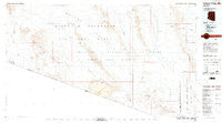
Cabeza Prieta Mts, Arizona, USGS topographic map dated 1980.
Includes geographic coordinates (latitude and longitude). This topographic map is suitable for hiking, camping, and exploring, or framing it as a wall map.
Printed on-demand using high resolution imagery, on heavy weight and acid free paper, or alternatively on a variety of synthetic materials.
Topos available on paper, Waterproof, Poly, or Tyvek. Usually shipping rolled, unless combined with other folded maps in one order.
- Product Number: USGS-5549078
- Free digital map download (high-resolution, GeoPDF): Cabeza Prieta Mts, Arizona (file size: 16 MB)
- Map Size: please refer to the dimensions of the GeoPDF map above
- Weight (paper map): ca. 55 grams
- Map Type: POD USGS Topographic Map
- Map Series: HTMC
- Map Verison: Historical
- Cell ID: 67208
- Scan ID: 315233
- Imprint Year: 1996
- Aerial Photo Year: 1973
- Edit Year: 1980
- Datum: NAD27
- Map Projection: Universal Transverse Mercator
- Map published by United States Geological Survey
- Map Language: English
- Scanner Resolution: 600 dpi
- Map Cell Name: Cabeza Prieta Mountains
- Grid size: 30 X 60 Minute
- Date on map: 1980
- Map Scale: 1:100000
- Geographical region: Arizona, United States
Neighboring Maps:
All neighboring USGS topo maps are available for sale online at a variety of scales.
Spatial coverage:
Topo map Cabeza Prieta Mts, Arizona, covers the geographical area associated the following places:
- Tordillo Mountain - Agua Dulce Mountains - North Pinta Tank - Papago Well - Growler Mountains - Sierra Arida - Pack Rat Hill - La Jolla Wash - Lechuguilla Desert - Cabeza Prieta Mountains - Rasmussen Mine - Sheep Mountain - Pinta Sands - Drift Hills - Bean Pass - Agua Dulce Pass - Charlie Bell Well - Cabeza Prieta Wilderness - Sierra de la Lechuguilla - Papago Mountain - Coyote Water - Eagle Canyon - Davidson Canyon - Chia Canyon - McMillan Mine - Pozo Nuevo Well - Smoke Tree Wash - Surprise Canyon - Copper Mountains - Hummingbird Canyon - Pinta Playa - Bryan Mountains - Growler Peak - Heart Tank - Tule Desert - Granite Pass Tank - Las Playas - O'Neills Grave - Palo Verde Camp - Buck Peak - Antelope Hills - O'Neill Hills - Halfway Tank - Isla Pinta - Deer Hollow - Christmas Pass - Dos Playas - Lower Well - Cabeza Prieta National Wildlife Refuge - Chico Shunie Temporal - Cabeza Prieta Peak - Pinacate Valley - Tule Tank - Tuseral Tank - Jose Juan Tank - Temporal Pass - Senita Tank - Monument Bluff - Paradise Canyon - Sunday Pass - Antelope Tank - Salt Well - Chico Shunie Arroyo - Tule Well - Monreal Well - Bassarisc Tank - A-one Basin - Papago Mine - Chinaman Flat - Cabeza Prieta Tanks - What Fo Canyon - Eagle Tank - Tule Mountains - Point of the Pintas - Bell Mine - Cipriano Well - Catch Basin - Buckhorn Tank - Agua Dulce Spring - Devil Hills - Jacks Well - Pinacate Lava Flow - Redtail Tank - Saguaro Gap Well - Sheep Peak - Venegas Prospects - Saguaro Gap - Cabeza Prieta Game Range - Charlie Bell Pass - Granite Mountains - Sierra Pinta - Cholla Pass - O'Neill Pass - Sinita Tank - Parra Tank - Papago Wash - Sheep Tank - Tule Wash - Camino Del Diablo - Cabeza Prieta Pass
- Map Area ID: AREA32.532-114-113
- Northwest corner Lat/Long code: USGSNW32.5-114
- Northeast corner Lat/Long code: USGSNE32.5-113
- Southwest corner Lat/Long code: USGSSW32-114
- Southeast corner Lat/Long code: USGSSE32-113
- Northern map edge Latitude: 32.5
- Southern map edge Latitude: 32
- Western map edge Longitude: -114
- Eastern map edge Longitude: -113


