
~ Bradshaw Mts AZ topo map, 1:100000 scale, 30 X 60 Minute, Historical, 1981, updated 1996
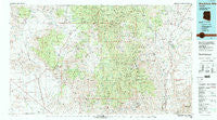
Bradshaw Mts, Arizona, USGS topographic map dated 1981.
Includes geographic coordinates (latitude and longitude). This topographic map is suitable for hiking, camping, and exploring, or framing it as a wall map.
Printed on-demand using high resolution imagery, on heavy weight and acid free paper, or alternatively on a variety of synthetic materials.
Topos available on paper, Waterproof, Poly, or Tyvek. Usually shipping rolled, unless combined with other folded maps in one order.
- Product Number: USGS-5549076
- Free digital map download (high-resolution, GeoPDF): Bradshaw Mts, Arizona (file size: 30 MB)
- Map Size: please refer to the dimensions of the GeoPDF map above
- Weight (paper map): ca. 55 grams
- Map Type: POD USGS Topographic Map
- Map Series: HTMC
- Map Verison: Historical
- Cell ID: 67178
- Scan ID: 315231
- Imprint Year: 1996
- Woodland Tint: Yes
- Aerial Photo Year: 1978
- Edit Year: 1981
- Datum: NAD27
- Map Projection: Universal Transverse Mercator
- Map published by United States Geological Survey
- Map Language: English
- Scanner Resolution: 600 dpi
- Map Cell Name: Bradshaw Mountains
- Grid size: 30 X 60 Minute
- Date on map: 1981
- Map Scale: 1:100000
- Geographical region: Arizona, United States
Neighboring Maps:
All neighboring USGS topo maps are available for sale online at a variety of scales.
Spatial coverage:
Topo map Bradshaw Mts, Arizona, covers the geographical area associated the following places:
- Hawkins - Bumble Bee - Cordes Junction - Walker - Venezia - Wilhoit - Breezy Pines - Columbia - Gillette - Congress - Briggs - South Fort - Cordes - Tip Top (historical) - McNary Place - Copperopolis - Kirkland - Burro John - Cleator - East Fort - Lehman Mill - Goodwin - Octave - Paxton Place - Glen Ilah - Minnehaha - Chilean Mill - Ferguson Place Windmill - Cordes Lakes - Piedmont - Potato Patch - Sand Mill - Lapham - Groom Creek - Ponderosa Park - Fort Misery - Arcosanti - Yarnell - Baldwin Place - Rock Springs - Dandrea - Hooper - Bradshaw City - Mayer - Humbug - Kirkland Junction - Black Canyon City - Grand View - Walnut Grove - Crown King - Flores - Constellation - Poland Junction - Walker Place Windmill - Glen Oaks - Congress Junction - Ocotillo - Date - Wagoner - Stanton - Peeples Valley - Yava - Packer - Hillside - Spring Valley - Rush Place Windmill
- Map Area ID: AREA34.534-113-112
- Northwest corner Lat/Long code: USGSNW34.5-113
- Northeast corner Lat/Long code: USGSNE34.5-112
- Southwest corner Lat/Long code: USGSSW34-113
- Southeast corner Lat/Long code: USGSSE34-112
- Northern map edge Latitude: 34.5
- Southern map edge Latitude: 34
- Western map edge Longitude: -113
- Eastern map edge Longitude: -112


