
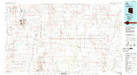
~ Ajo AZ topo map, 1:100000 scale, 30 X 60 Minute, Historical, 1980, updated 1996
Ajo, Arizona, USGS topographic map dated 1980.
Includes geographic coordinates (latitude and longitude). This topographic map is suitable for hiking, camping, and exploring, or framing it as a wall map.
Printed on-demand using high resolution imagery, on heavy weight and acid free paper, or alternatively on a variety of synthetic materials.
Topos available on paper, Waterproof, Poly, or Tyvek. Usually shipping rolled, unless combined with other folded maps in one order.
- Product Number: USGS-5549062
- Free digital map download (high-resolution, GeoPDF): Ajo, Arizona (file size: 20 MB)
- Map Size: please refer to the dimensions of the GeoPDF map above
- Weight (paper map): ca. 55 grams
- Map Type: POD USGS Topographic Map
- Map Series: HTMC
- Map Verison: Historical
- Cell ID: 67020
- Scan ID: 315226
- Imprint Year: 1996
- Woodland Tint: Yes
- Aerial Photo Year: 1972
- Edit Year: 1980
- Datum: NAD27
- Map Projection: Universal Transverse Mercator
- Map published by United States Geological Survey
- Map Language: English
- Scanner Resolution: 600 dpi
- Map Cell Name: Ajo
- Grid size: 30 X 60 Minute
- Date on map: 1980
- Map Scale: 1:100000
- Geographical region: Arizona, United States
Neighboring Maps:
All neighboring USGS topo maps are available for sale online at a variety of scales.
Spatial coverage:
Topo map Ajo, Arizona, covers the geographical area associated the following places:
- Ahan Owuch - Emika - Kuakatch - Narcho Santos - Pisinemo - Gu Vo - Santa Rosa - Hotason Vo - Rowood - Charco - Gibson - Ali Oidak - Achi - Gurli Put Vo - Peach Pu - Hickiwan - Vainom Kug - Hali Murk - Chico Shunie - Piato Vaya - Wahak Hotrontk - Kui Tatk - Sikort Chuapo - Stotonyak - Why - Schuchuli - Stoa Pitk - Sikul Himatk - Oit Ihuk - Maish Vaya - Childs - Noipa Kam - Anegam - San Luis - Hoa Murk - Ventana - Quijotoa - Vaya Chin - Tatai Toak - Kaihon Kug - Pisinimo - Viason Chin - Ak Chin - Ajo - Komak Wuacho - Palo Verde Stand - Mexican Town
- Map Area ID: AREA32.532-113-112
- Northwest corner Lat/Long code: USGSNW32.5-113
- Northeast corner Lat/Long code: USGSNE32.5-112
- Southwest corner Lat/Long code: USGSSW32-113
- Southeast corner Lat/Long code: USGSSE32-112
- Northern map edge Latitude: 32.5
- Southern map edge Latitude: 32
- Western map edge Longitude: -113
- Eastern map edge Longitude: -112


