
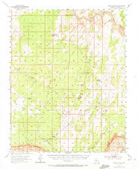
~ Paria Plateau AZ topo map, 1:62500 scale, 15 X 15 Minute, Historical, 1954, updated 1972
Paria Plateau, Arizona, USGS topographic map dated 1954.
Includes geographic coordinates (latitude and longitude). This topographic map is suitable for hiking, camping, and exploring, or framing it as a wall map.
Printed on-demand using high resolution imagery, on heavy weight and acid free paper, or alternatively on a variety of synthetic materials.
Topos available on paper, Waterproof, Poly, or Tyvek. Usually shipping rolled, unless combined with other folded maps in one order.
- Product Number: USGS-5548412
- Free digital map download (high-resolution, GeoPDF): Paria Plateau, Arizona (file size: 6 MB)
- Map Size: please refer to the dimensions of the GeoPDF map above
- Weight (paper map): ca. 55 grams
- Map Type: POD USGS Topographic Map
- Map Series: HTMC
- Map Verison: Historical
- Cell ID: 60756
- Scan ID: 314872
- Imprint Year: 1972
- Woodland Tint: Yes
- Aerial Photo Year: 1951
- Field Check Year: 1954
- Datum: NAD27
- Map Projection: Polyconic
- Map published by United States Geological Survey
- Map Language: English
- Scanner Resolution: 600 dpi
- Map Cell Name: Paria Plateau
- Grid size: 15 X 15 Minute
- Date on map: 1954
- Map Scale: 1:62500
- Geographical region: Arizona, United States
Neighboring Maps:
All neighboring USGS topo maps are available for sale online at a variety of scales.
Spatial coverage:
Topo map Paria Plateau, Arizona, covers the geographical area associated the following places:
- Soap Creek Number Two Tank - Soap Creek Number One Tank - Judd Hollow - Badger Tank - Joes Tank - The Hole - Paria Plateau - Big Sink - Joes Ranch - Soap Creek Pasture - Black Valley - Wrather Arch - Paria Canyon-Vermilion Cliffs Wilderness - Vermilion Cliffs National Monument - Judd Hollow - Lower Reservoir - Cottonwood Cove - Middle Reservoir - Wolf Knoll - Big Pocket - Pine Tree Pockets - Jarvis Ranch - Hole in the Rock - Pinnacle Valley - Middle Knoll - Little Knoll - One Toe Ridge - Lynn Tank - The Big Knoll - Quaking Aspen Tank - Sand Hills - White Pocket - Sandhill Ranch Airport - Red Knolls - White Knolls - Franks - Red Pocket - Kid Pen Valley - Cottonwood Spring - Pinnacle Ridge - Pinnacle Valley Well - Moquitch Tank - Mexican Sink
- Map Area ID: AREA3736.75-112-111.75
- Northwest corner Lat/Long code: USGSNW37-112
- Northeast corner Lat/Long code: USGSNE37-111.75
- Southwest corner Lat/Long code: USGSSW36.75-112
- Southeast corner Lat/Long code: USGSSE36.75-111.75
- Northern map edge Latitude: 37
- Southern map edge Latitude: 36.75
- Western map edge Longitude: -112
- Eastern map edge Longitude: -111.75


