
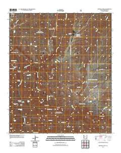
~ Kennedy Peak AZ topo map, 1:24000 scale, 7.5 X 7.5 Minute, Historical, 2011
Kennedy Peak, Arizona, USGS topographic map dated 2011.
Includes geographic coordinates (latitude and longitude). This topographic map is suitable for hiking, camping, and exploring, or framing it as a wall map.
Printed on-demand using high resolution imagery, on heavy weight and acid free paper, or alternatively on a variety of synthetic materials.
Topos available on paper, Waterproof, Poly, or Tyvek. Usually shipping rolled, unless combined with other folded maps in one order.
- Product Number: USGS-5547102
- Free digital map download (high-resolution, GeoPDF): Kennedy Peak, Arizona (file size: 24 MB)
- Map Size: please refer to the dimensions of the GeoPDF map above
- Weight (paper map): ca. 55 grams
- Map Type: POD USGS Topographic Map
- Map Series: US Topo
- Map Verison: Historical
- Cell ID: 23327
- Datum: North American Datum of 1983
- Map Projection: Transverse Mercator
- Map Cell Name: Kennedy Peak
- Grid size: 7.5 X 7.5 Minute
- Date on map: 2011
- Map Scale: 1:24000
- Geographical region: Arizona, United States
Neighboring Maps:
All neighboring USGS topo maps are available for sale online at a variety of scales.
Spatial coverage:
Topo map Kennedy Peak, Arizona, covers the geographical area associated the following places:
- Paddys River Two hundred ninety three Trail - Double Trough Spring - Willow Creek - Powers Hill - China Peak - Junniper Springs Two hundred ninety five Trail - South Field Canyon - Roy Tank - Corral Canyon - Peach Tree Tank - Rockhouse Peak - Corral Spring - Powers Garden - Squaw Saddle - Horse Canyon - Grapevine Spring - Horse Canyon Tank - Mud Spring - Bluff Spring - Pipestem Canyon - Mailbox Canyon - Mud Spring - Deer Creek Cabin - Willow Spring - China Peak Observatory Airport - Grassy Ridge - Oak Spring - Powers Garden Ninety Six Trail - Home Ranch Tank - Deer Creek Ranch - Upper Ringtail Tank - China Peak Observatory - Upper Sycamore Tank - Sycamore Creek - Horse Canyon Trail Number Two hundred fifty four - Ringtail Canyon - Kennedy Peak - Brush Canyon - North Tank - Horse Mountain - Corral Tank - Apache Tank - Powers Garden Spring - Limestone Spring - Lower Ringtail Tank - Douglas Canyon - Topout Divide - Lower Sycamore Tank - Horse Camp Corral - Prude Ranch - Topout Peak - North Field Canyon - Rattlesnake Mesa
- Map Area ID: AREA32.7532.625-110.375-110.25
- Northwest corner Lat/Long code: USGSNW32.75-110.375
- Northeast corner Lat/Long code: USGSNE32.75-110.25
- Southwest corner Lat/Long code: USGSSW32.625-110.375
- Southeast corner Lat/Long code: USGSSE32.625-110.25
- Northern map edge Latitude: 32.75
- Southern map edge Latitude: 32.625
- Western map edge Longitude: -110.375
- Eastern map edge Longitude: -110.25


