
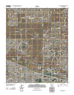
~ Currys Corner AZ topo map, 1:24000 scale, 7.5 X 7.5 Minute, Historical, 2011
Currys Corner, Arizona, USGS topographic map dated 2011.
Includes geographic coordinates (latitude and longitude). This topographic map is suitable for hiking, camping, and exploring, or framing it as a wall map.
Printed on-demand using high resolution imagery, on heavy weight and acid free paper, or alternatively on a variety of synthetic materials.
Topos available on paper, Waterproof, Poly, or Tyvek. Usually shipping rolled, unless combined with other folded maps in one order.
- Product Number: USGS-5546472
- Free digital map download (high-resolution, GeoPDF): Currys Corner, Arizona (file size: 27 MB)
- Map Size: please refer to the dimensions of the GeoPDF map above
- Weight (paper map): ca. 55 grams
- Map Type: POD USGS Topographic Map
- Map Series: US Topo
- Map Verison: Historical
- Cell ID: 11068
- Datum: North American Datum of 1983
- Map Projection: Transverse Mercator
- Map Cell Name: Currys Corner
- Grid size: 7.5 X 7.5 Minute
- Date on map: 2011
- Map Scale: 1:24000
- Geographical region: Arizona, United States
Neighboring Maps:
All neighboring USGS topo maps are available for sale online at a variety of scales.
Spatial coverage:
Topo map Currys Corner, Arizona, covers the geographical area associated the following places:
- Sandalwood - Heritage North Ranch - Windsong - Pinnacle Peak Estates II - Happy Valley Ranch - Paradise Valley Miranda - Desert Highlands - Desert Ridge - Currys Corner - Basking Ridge - Bell Acres Mobile Home Park - Pinnacle Peak Estates III - Pinnacle Peak Village - Pinnacle Peak Estates I - Greenway Park V - Pinnacle Peak Country Club Estates - Montclair Terrace - Country Trace - Pinnacle Peak Shadows - Paradise Peak West Mobile Home Park - Rancho Santa Fe - Sunset Ridge I - Pinnacle Paradise - Quail Valley - Oakhurst
- Map Area ID: AREA33.7533.625-112-111.875
- Northwest corner Lat/Long code: USGSNW33.75-112
- Northeast corner Lat/Long code: USGSNE33.75-111.875
- Southwest corner Lat/Long code: USGSSW33.625-112
- Southeast corner Lat/Long code: USGSSE33.625-111.875
- Northern map edge Latitude: 33.75
- Southern map edge Latitude: 33.625
- Western map edge Longitude: -112
- Eastern map edge Longitude: -111.875


