
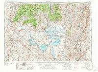
~ Burns OR topo map, 1:250000 scale, 1 X 2 Degree, Historical, 1955, updated 1972
Burns, Oregon, USGS topographic map dated 1955.
Includes geographic coordinates (latitude and longitude). This topographic map is suitable for hiking, camping, and exploring, or framing it as a wall map.
Printed on-demand using high resolution imagery, on heavy weight and acid free paper, or alternatively on a variety of synthetic materials.
Topos available on paper, Waterproof, Poly, or Tyvek. Usually shipping rolled, unless combined with other folded maps in one order.
- Product Number: USGS-5545844
- Free digital map download (high-resolution, GeoPDF): Burns, Oregon (file size: 22 MB)
- Map Size: please refer to the dimensions of the GeoPDF map above
- Weight (paper map): ca. 55 grams
- Map Type: POD USGS Topographic Map
- Map Series: HTMC
- Map Verison: Historical
- Cell ID: 68697
- Scan ID: 283305
- Imprint Year: 1972
- Woodland Tint: Yes
- Visual Version Number: 1
- Aerial Photo Year: 1953
- Edit Year: 1970
- Field Check Year: 1955
- Datum: Unstated
- Map Projection: Transverse Mercator
- Map published by United States Geological Survey
- Map published by: Military, Other
- Map Language: English
- Scanner Resolution: 600 dpi
- Map Cell Name: Burns
- Grid size: 1 X 2 Degree
- Date on map: 1955
- Map Scale: 1:250000
- Geographical region: Oregon, United States
Neighboring Maps:
All neighboring USGS topo maps are available for sale online at a variety of scales.
Spatial coverage:
Topo map Burns, Oregon, covers the geographical area associated the following places:
- Indian Village - Crane - Harney - New Princeton - Juntura - Riley - Narrows - Diamond - Suntex - Dunnean - Beulah - Buchanan - Princeton (historical) - Drewsey - Creston - Cord (historical) - Burns - Hines - Van - Riverside - Venator - Lawen - Wagontire - Voltage - Trout Creek
- Map Area ID: AREA4443-120-118
- Northwest corner Lat/Long code: USGSNW44-120
- Northeast corner Lat/Long code: USGSNE44-118
- Southwest corner Lat/Long code: USGSSW43-120
- Southeast corner Lat/Long code: USGSSE43-118
- Northern map edge Latitude: 44
- Southern map edge Latitude: 43
- Western map edge Longitude: -120
- Eastern map edge Longitude: -118


