
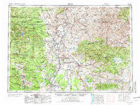
~ Bend OR topo map, 1:250000 scale, 1 X 2 Degree, Historical, 1955, updated 1973
Bend, Oregon, USGS topographic map dated 1955.
Includes geographic coordinates (latitude and longitude). This topographic map is suitable for hiking, camping, and exploring, or framing it as a wall map.
Printed on-demand using high resolution imagery, on heavy weight and acid free paper, or alternatively on a variety of synthetic materials.
Topos available on paper, Waterproof, Poly, or Tyvek. Usually shipping rolled, unless combined with other folded maps in one order.
- Product Number: USGS-5545838
- Free digital map download (high-resolution, GeoPDF): Bend, Oregon (file size: 23 MB)
- Map Size: please refer to the dimensions of the GeoPDF map above
- Weight (paper map): ca. 55 grams
- Map Type: POD USGS Topographic Map
- Map Series: HTMC
- Map Verison: Historical
- Cell ID: 75019
- Scan ID: 283302
- Imprint Year: 1973
- Woodland Tint: Yes
- Visual Version Number: 2
- Aerial Photo Year: 1953
- Edit Year: 1971
- Field Check Year: 1955
- Datum: Unstated
- Map Projection: Transverse Mercator
- Map published by United States Geological Survey
- Map published by: Military, Other
- Map Language: English
- Scanner Resolution: 600 dpi
- Map Cell Name: Bend
- Grid size: 1 X 2 Degree
- Date on map: 1955
- Map Scale: 1:250000
- Geographical region: Oregon, United States
Neighboring Maps:
All neighboring USGS topo maps are available for sale online at a variety of scales.
Spatial coverage:
Topo map Bend, Oregon, covers the geographical area associated the following places:
- Breitenbush - Grandview - Crooked River Ranch - Camp Sherman - Culver - Lamonta (historical) - Sisters - Warm Springs - Lower Bridge (historical) - Geneva - Madras - Ashwood - Horseheaven - Post - Black Butte Ranch - Kilts - Cline Falls (historical) - Prineville - Fossil - Simnasho - Axehandle (historical) - Forest Crossing - Terrebonne - Deschutes - Cloverdale - Bend - Metolius - Marion Forks - Powell Butte - Donnybrook (historical) - Twickenham - Service Creek - Tumalo - Willowdale - Clarno - Gateway - Alfalfa - Grizzly - Redmond - Mitchell - Antelope - Kinzua (historical) - Roberts - Breitenbush Hot Springs - Waldron (historical) - Opal City
- Map Area ID: AREA4544-122-120
- Northwest corner Lat/Long code: USGSNW45-122
- Northeast corner Lat/Long code: USGSNE45-120
- Southwest corner Lat/Long code: USGSSW44-122
- Southeast corner Lat/Long code: USGSSE44-120
- Northern map edge Latitude: 45
- Southern map edge Latitude: 44
- Western map edge Longitude: -122
- Eastern map edge Longitude: -120


