
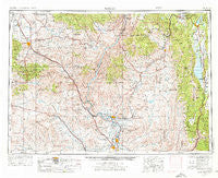
~ Baker OR topo map, 1:250000 scale, 1 X 2 Degree, Historical, 1955, updated 1976
Baker, Oregon, USGS topographic map dated 1955.
Includes geographic coordinates (latitude and longitude). This topographic map is suitable for hiking, camping, and exploring, or framing it as a wall map.
Printed on-demand using high resolution imagery, on heavy weight and acid free paper, or alternatively on a variety of synthetic materials.
Topos available on paper, Waterproof, Poly, or Tyvek. Usually shipping rolled, unless combined with other folded maps in one order.
- Product Number: USGS-5545828
- Free digital map download (high-resolution, GeoPDF): Baker, Oregon (file size: 23 MB)
- Map Size: please refer to the dimensions of the GeoPDF map above
- Weight (paper map): ca. 55 grams
- Map Type: POD USGS Topographic Map
- Map Series: HTMC
- Map Verison: Historical
- Cell ID: 68660
- Scan ID: 283297
- Imprint Year: 1976
- Woodland Tint: Yes
- Visual Version Number: 1
- Aerial Photo Year: 1953
- Edit Year: 1974
- Field Check Year: 1955
- Datum: Unstated
- Map Projection: Transverse Mercator
- Map published by United States Geological Survey
- Map published by: Military, Other
- Map Language: English
- Scanner Resolution: 600 dpi
- Map Cell Name: Baker City
- Grid size: 1 X 2 Degree
- Date on map: 1955
- Map Scale: 1:250000
- Geographical region: Oregon, United States
Neighboring Maps:
All neighboring USGS topo maps are available for sale online at a variety of scales.
Spatial coverage:
Topo map Baker, Oregon, covers the geographical area associated the following places:
- Fruitvale - Starkey - Dale (historical) - Hillsdale (historical) - Dennis - Eiffie - Elo (historical) - Malheur City (historical) - Mesa - Council - Woodland - Keating - French Corner - Wood - Salubria - Eldorado - Brownlee - Crystal - Baker City - Rye Valley - Hoover - Williams Creek Summit Home Area - Jett (historical) - Cambridge - Tamarack - Pine Ridge - Fruitland - Alpine - Concrete - Sunset - Sparta - Crane (historical) - Conner Creek (historical) - Mineral - Wildhorse - Bridgeport - Warm Springs (historical) - Midvale - Humboldt Basin (historical) - Oxbow (historical) - Brogan - McCall - Pleasant Valley - Cascade - Gayway Corner - Archabal - Dell (historical) - Halfway - Fort Wilson - Lime - Brownlee - Encina - Arling - New Meadows - Beer Bottle Crossing - Alpha - Big Eddy - Indian Valley - Auburn (historical) - Jamieson - Haines - Rubicon - Roseberry - Pine Creek - Huntington - Cabarton - Belvidere - Stevens - Weiser - Norwood - Pine - Clarksville - Banks - Washoe - Meadows - Clover (historical) - Smiths Ferry - Spink - Evergreen - Durkee - Diamond - Payette Heights - Home (historical) - Jonathan - Carson - Ramey - Weatherby - Bacon - Heath - Cake (historical) - Annex - Robinette - Payette - Hutchinson - Wingville - Goodrich - Erwin (historical) - Glendale - Jimtown - Bonita
- Map Area ID: AREA4544-118-116
- Northwest corner Lat/Long code: USGSNW45-118
- Northeast corner Lat/Long code: USGSNE45-116
- Southwest corner Lat/Long code: USGSSW44-118
- Southeast corner Lat/Long code: USGSSE44-116
- Northern map edge Latitude: 45
- Southern map edge Latitude: 44
- Western map edge Longitude: -118
- Eastern map edge Longitude: -116


