
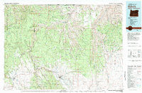
~ Wallowa OR topo map, 1:100000 scale, 30 X 60 Minute, Historical, 1982, updated 1983
Wallowa, Oregon, USGS topographic map dated 1982.
Includes geographic coordinates (latitude and longitude). This topographic map is suitable for hiking, camping, and exploring, or framing it as a wall map.
Printed on-demand using high resolution imagery, on heavy weight and acid free paper, or alternatively on a variety of synthetic materials.
Topos available on paper, Waterproof, Poly, or Tyvek. Usually shipping rolled, unless combined with other folded maps in one order.
- Product Number: USGS-5545806
- Free digital map download (high-resolution, GeoPDF): Wallowa, Oregon (file size: 32 MB)
- Map Size: please refer to the dimensions of the GeoPDF map above
- Weight (paper map): ca. 55 grams
- Map Type: POD USGS Topographic Map
- Map Series: HTMC
- Map Verison: Historical
- Cell ID: 68545
- Scan ID: 283127
- Imprint Year: 1983
- Woodland Tint: Yes
- Visual Version Number: 2
- Aerial Photo Year: 1976
- Edit Year: 1982
- Datum: NAD27
- Map Projection: Universal Transverse Mercator
- Map published by United States Geological Survey
- Map Language: English
- Scanner Resolution: 600 dpi
- Map Cell Name: Wallowa
- Grid size: 30 X 60 Minute
- Date on map: 1982
- Map Scale: 1:100000
- Geographical region: Oregon, United States
Neighboring Maps:
All neighboring USGS topo maps are available for sale online at a variety of scales.
Spatial coverage:
Topo map Wallowa, Oregon, covers the geographical area associated the following places:
- Grouse - Indian Valley (historical) - Eden - Elgin - Grossman (historical) - Wallowa - Elk Flat (historical) - Promise - Eustis (historical) - Looking Glass (historical) - Cabin Creek (historical) - Minam - Evans - Troy - Lewis - Paradise - Bartlett - Chico (historical) - Maxville - Flora
- Map Area ID: AREA4645.5-118-117
- Northwest corner Lat/Long code: USGSNW46-118
- Northeast corner Lat/Long code: USGSNE46-117
- Southwest corner Lat/Long code: USGSSW45.5-118
- Southeast corner Lat/Long code: USGSSE45.5-117
- Northern map edge Latitude: 46
- Southern map edge Latitude: 45.5
- Western map edge Longitude: -118
- Eastern map edge Longitude: -117


