
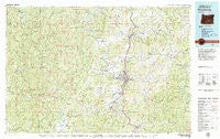
~ Roseburg OR topo map, 1:100000 scale, 30 X 60 Minute, Historical, 1979, updated 1979
Roseburg, Oregon, USGS topographic map dated 1979.
Includes geographic coordinates (latitude and longitude). This topographic map is suitable for hiking, camping, and exploring, or framing it as a wall map.
Printed on-demand using high resolution imagery, on heavy weight and acid free paper, or alternatively on a variety of synthetic materials.
Topos available on paper, Waterproof, Poly, or Tyvek. Usually shipping rolled, unless combined with other folded maps in one order.
- Product Number: USGS-5545788
- Free digital map download (high-resolution, GeoPDF): Roseburg, Oregon (file size: 32 MB)
- Map Size: please refer to the dimensions of the GeoPDF map above
- Weight (paper map): ca. 55 grams
- Map Type: POD USGS Topographic Map
- Map Series: HTMC
- Map Verison: Historical
- Cell ID: 68262
- Scan ID: 283118
- Imprint Year: 1979
- Woodland Tint: Yes
- Aerial Photo Year: 1976
- Edit Year: 1979
- Datum: NAD27
- Map Projection: Universal Transverse Mercator
- Map published by United States Geological Survey
- Map Language: English
- Scanner Resolution: 600 dpi
- Map Cell Name: Roseburg
- Grid size: 30 X 60 Minute
- Date on map: 1979
- Map Scale: 1:100000
- Geographical region: Oregon, United States
Neighboring Maps:
All neighboring USGS topo maps are available for sale online at a variety of scales.
Spatial coverage:
Topo map Roseburg, Oregon, covers the geographical area associated the following places:
- Camas Valley - Nugget (historical) - Lookingglass - Riversdale - Green - Calkins - Myrtle Creek - Tenmile - Old Town - Dixonville - Stephens - Callahan - Winchester - Hawthorne - Buck Fork (historical) - Porter Creek - Winston - Dillard - Fair Oaks - Oakland - Brockway - Melrose - Cleveland - Umpqua - Oak Creek (historical) - Roseburg - Peel - Dora - Millwood - Olalla - Rockland (historical) - Reston - Glide - Weaver - Idleyld Park - Edenbower - Sutherlin - Tyee - Sitkum - Round Prairie - Wilbur - Coles Valley - Hoaglin (historical) - Oaks - Remote - Elgarose - Union Gap - Civil Bend (historical)
- Map Area ID: AREA43.543-124-123
- Northwest corner Lat/Long code: USGSNW43.5-124
- Northeast corner Lat/Long code: USGSNE43.5-123
- Southwest corner Lat/Long code: USGSSW43-124
- Southeast corner Lat/Long code: USGSSE43-123
- Northern map edge Latitude: 43.5
- Southern map edge Latitude: 43
- Western map edge Longitude: -124
- Eastern map edge Longitude: -123


