
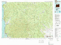
~ Nehalem River OR topo map, 1:100000 scale, 30 X 60 Minute, Historical, 1979, updated 1989
Nehalem River, Oregon, USGS topographic map dated 1979.
Includes geographic coordinates (latitude and longitude). This topographic map is suitable for hiking, camping, and exploring, or framing it as a wall map.
Printed on-demand using high resolution imagery, on heavy weight and acid free paper, or alternatively on a variety of synthetic materials.
Topos available on paper, Waterproof, Poly, or Tyvek. Usually shipping rolled, unless combined with other folded maps in one order.
- Product Number: USGS-5545768
- Free digital map download (high-resolution, GeoPDF): Nehalem River, Oregon (file size: 35 MB)
- Map Size: please refer to the dimensions of the GeoPDF map above
- Weight (paper map): ca. 55 grams
- Map Type: POD USGS Topographic Map
- Map Series: HTMC
- Map Verison: Historical
- Cell ID: 72182
- Scan ID: 283107
- Imprint Year: 1989
- Woodland Tint: Yes
- Aerial Photo Year: 1975
- Edit Year: 1979
- Datum: NAD27
- Map Projection: Universal Transverse Mercator
- Map published by United States Geological Survey
- Map Language: English
- Scanner Resolution: 600 dpi
- Map Cell Name: Nehalem River
- Grid size: 30 X 60 Minute
- Date on map: 1979
- Map Scale: 1:100000
- Geographical region: Oregon, United States
Neighboring Maps:
All neighboring USGS topo maps are available for sale online at a variety of scales.
Spatial coverage:
Topo map Nehalem River, Oregon, covers the geographical area associated the following places:
- Bay City - Kansas City - Glenwood - Enright - Hayward - Clear Creek - Idaville - Neahkahnie - Aldervale - Wheeler - Barview - Hobsonville - Grand Rapids - Carnation - Treharne - Pittsburg - Manhattan Beach - Jordan Creek - Wilkesboro - Mountaindale - Twin Rocks - Corey Hill - Vinemaple - Foley (historical) - Bacona - Bayocean (historical) - Centerville (historical) - Tideport - Balm Grove - Necanicum (historical) - Batterson - Hillside - Denver (historical) - Gales Creek - Cannon Beach - Lukarilla - Garibaldi - Vernonia - Barnesdale - Buxton - Brighton - Westimber (historical) - Neverstill - Wheeler Heights - Jewell - Manzanita - Neahkahnie Beach - Rockaway Beach - Mist - Keasey - Forest Grove - Tolovana Park - Mohler - Birkenfeld - Nedonna Beach - Manning - Mishawaka - Bayside Gardens - Cornelius - Timber - Nehalem - Barnegat (historical) - Hamlet - Foss - Elsie - Arch Cape - Banks - Verboort - Watts - Dixie (historical) - Seaside - Saltair (historical)
- Map Area ID: AREA4645.5-124-123
- Northwest corner Lat/Long code: USGSNW46-124
- Northeast corner Lat/Long code: USGSNE46-123
- Southwest corner Lat/Long code: USGSSW45.5-124
- Southeast corner Lat/Long code: USGSSE45.5-123
- Northern map edge Latitude: 46
- Southern map edge Latitude: 45.5
- Western map edge Longitude: -124
- Eastern map edge Longitude: -123


