
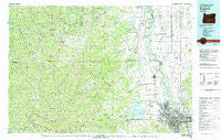
~ Eugene OR topo map, 1:100000 scale, 30 X 60 Minute, Historical, 1980, updated 1980
Eugene, Oregon, USGS topographic map dated 1980.
Includes geographic coordinates (latitude and longitude). This topographic map is suitable for hiking, camping, and exploring, or framing it as a wall map.
Printed on-demand using high resolution imagery, on heavy weight and acid free paper, or alternatively on a variety of synthetic materials.
Topos available on paper, Waterproof, Poly, or Tyvek. Usually shipping rolled, unless combined with other folded maps in one order.
- Product Number: USGS-5545710
- Free digital map download (high-resolution, GeoPDF): Eugene, Oregon (file size: 32 MB)
- Map Size: please refer to the dimensions of the GeoPDF map above
- Weight (paper map): ca. 55 grams
- Map Type: POD USGS Topographic Map
- Map Series: HTMC
- Map Verison: Historical
- Cell ID: 67489
- Scan ID: 283075
- Imprint Year: 1980
- Woodland Tint: Yes
- Aerial Photo Year: 1975
- Edit Year: 1980
- Datum: NAD27
- Map Projection: Universal Transverse Mercator
- Map published by United States Geological Survey
- Map Language: English
- Scanner Resolution: 600 dpi
- Map Cell Name: Eugene
- Grid size: 30 X 60 Minute
- Date on map: 1980
- Map Scale: 1:100000
- Geographical region: Oregon, United States
Neighboring Maps:
All neighboring USGS topo maps are available for sale online at a variety of scales.
Spatial coverage:
Topo map Eugene, Oregon, covers the geographical area associated the following places:
- Alpine - Coburg - North Springfield - Irving - Noti - Glenwood - Alpha - Mapleton - Bethel - Horton - Shedd - Drift Creek - Burlington (historical) - Glenbrook - Walton - Euclid (historical) - Bellfountain - Fisher - Brickerville - Tiernan - Starrs Point (historical) - Swisshome - Lancaster - Monroe - Minerva - Estrup (historical) - Eugene - Point Terrace - Triangle Lake - Alsea Rivera - Deadwood - Fir Grove - Tidewater - Harrisburg - Indiola - Denzer (historical) - Springfield - Little Albany - College Hill - Elmira - Danebo - Tide - Paris - Little Switzerland - Cheshire - Junction City - Linville (historical) - River Road - Santa Clara - Linslaw - Franklin - Peoria - Blachly - Westwood Village - Vaughn - Low Pass - Reed - Goldson - Fern Ridge Shores - Greenleaf - Rainrock - Halsey - Veneta - Alsea - Alvadore
- Map Area ID: AREA44.544-124-123
- Northwest corner Lat/Long code: USGSNW44.5-124
- Northeast corner Lat/Long code: USGSNE44.5-123
- Southwest corner Lat/Long code: USGSSW44-124
- Southeast corner Lat/Long code: USGSSE44-123
- Northern map edge Latitude: 44.5
- Southern map edge Latitude: 44
- Western map edge Longitude: -124
- Eastern map edge Longitude: -123


