
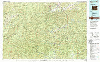
~ Canyonville OR topo map, 1:100000 scale, 30 X 60 Minute, Historical, 1989, updated 1989
Canyonville, Oregon, USGS topographic map dated 1989.
Includes geographic coordinates (latitude and longitude). This topographic map is suitable for hiking, camping, and exploring, or framing it as a wall map.
Printed on-demand using high resolution imagery, on heavy weight and acid free paper, or alternatively on a variety of synthetic materials.
Topos available on paper, Waterproof, Poly, or Tyvek. Usually shipping rolled, unless combined with other folded maps in one order.
- Product Number: USGS-5545680
- Free digital map download (high-resolution, GeoPDF): Canyonville, Oregon (file size: 36 MB)
- Map Size: please refer to the dimensions of the GeoPDF map above
- Weight (paper map): ca. 55 grams
- Map Type: POD USGS Topographic Map
- Map Series: HTMC
- Map Verison: Historical
- Cell ID: 67226
- Scan ID: 283060
- Imprint Year: 1989
- Woodland Tint: Yes
- Visual Version Number: 2
- Aerial Photo Year: 1982
- Edit Year: 1989
- Datum: NAD27
- Map Projection: Universal Transverse Mercator
- Map published by United States Geological Survey
- Map Language: English
- Scanner Resolution: 600 dpi
- Map Cell Name: Canyonville
- Grid size: 30 X 60 Minute
- Date on map: 1989
- Map Scale: 1:100000
- Geographical region: Oregon, United States
Neighboring Maps:
All neighboring USGS topo maps are available for sale online at a variety of scales.
Spatial coverage:
Topo map Canyonville, Oregon, covers the geographical area associated the following places:
- Cow Creek - Galice - Azalea - Merlin - Fortune Branch - Rand - Wimer - Quines Creek - Dads Creek - Golden - Fernvale - Placer - Hugo - Peck - Sunny Valley - Booth (historical) - Lavadoure (historical) - Tri City - Anchor (historical) - Marial - Milo - Surprise Valley - Greenback (historical) - Glendale - Days Creek - Riddle - Tri-City - Speaker - Pleasant Valley - Canyonville - Three Pines - Gazley - Galesville - Leland - Wolf Creek - Perdue (historical)
- Map Area ID: AREA4342.5-124-123
- Northwest corner Lat/Long code: USGSNW43-124
- Northeast corner Lat/Long code: USGSNE43-123
- Southwest corner Lat/Long code: USGSSW42.5-124
- Southeast corner Lat/Long code: USGSSE42.5-123
- Northern map edge Latitude: 43
- Southern map edge Latitude: 42.5
- Western map edge Longitude: -124
- Eastern map edge Longitude: -123


