
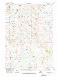
~ Stockade Mtn OR topo map, 1:62500 scale, 15 X 15 Minute, Historical, 1972, updated 1976
Stockade Mtn, Oregon, USGS topographic map dated 1972.
Includes geographic coordinates (latitude and longitude). This topographic map is suitable for hiking, camping, and exploring, or framing it as a wall map.
Printed on-demand using high resolution imagery, on heavy weight and acid free paper, or alternatively on a variety of synthetic materials.
Topos available on paper, Waterproof, Poly, or Tyvek. Usually shipping rolled, unless combined with other folded maps in one order.
- Product Number: USGS-5545418
- Free digital map download (high-resolution, GeoPDF): Stockade Mtn, Oregon (file size: 7 MB)
- Map Size: please refer to the dimensions of the GeoPDF map above
- Weight (paper map): ca. 55 grams
- Map Type: POD USGS Topographic Map
- Map Series: HTMC
- Map Verison: Historical
- Cell ID: 62991
- Scan ID: 282914
- Imprint Year: 1976
- Woodland Tint: Yes
- Aerial Photo Year: 1972
- Field Check Year: 1972
- Datum: NAD27
- Map Projection: Lambert Conformal Conic
- Map published by United States Geological Survey
- Map Language: English
- Scanner Resolution: 600 dpi
- Map Cell Name: Stockade Mountain
- Grid size: 15 X 15 Minute
- Date on map: 1972
- Map Scale: 1:62500
- Geographical region: Oregon, United States
Neighboring Maps:
All neighboring USGS topo maps are available for sale online at a variety of scales.
Spatial coverage:
Topo map Stockade Mtn, Oregon, covers the geographical area associated the following places:
- Venator Reservoir - Fort (historical) - Bar Heart Reservoir - Whitehorse Mountain - Juniper Creek - East Swamp Creek - Star Creek - Chapman Reservoir - Cat Reservoir - Robinson Creek - Granite Creek Reservoir - Stockade Mountain - Robinson Spring - Hickey Basin Reservoir - Summit Reservoir - Visher Creek - Jake Hughes Reservoir - Cobb Creek - McRae Homestead - Luce Hot Springs - Hickey Basin - Helpful Spring - Dog Spring - Box Canyon - Swamp Creek Ranch - Beers Dam - Dry Canyon - Soldier Spring - Buck Creek - White Reservoir - Section Line Reservoir - Pole Creek - Hot Springs Creek - Dipping Vat Spring - Hat Butte - Stockade Buttes - Mud Spring - Newts Waterhole - Cob Creek Dam - Atterbury Reservoir - Cables Ditch - Walls Reservoir - South Fork Visher Creek - Creston Cabin - Chapman Dam - Cobb Spring - Duck Pond - Coyote Springs - Big Flat - Visher Feed Canal - McEwen Creek - Dry Buttes - Long Canyon - McEwen Butte - New Visher Reservoir - Visher Reservoir - Buck Mountain - McEwen Reservoir - Lakebed Waterhole - Hat Butte Waterhole - Andy Wilson Reservoir - Swamp Creek Buttes - Meadow Creek - Head of the Creek Waterhole - Spurlock Ranch - McEwen Ranch
- Map Area ID: AREA43.543.25-118.25-118
- Northwest corner Lat/Long code: USGSNW43.5-118.25
- Northeast corner Lat/Long code: USGSNE43.5-118
- Southwest corner Lat/Long code: USGSSW43.25-118.25
- Southeast corner Lat/Long code: USGSSE43.25-118
- Northern map edge Latitude: 43.5
- Southern map edge Latitude: 43.25
- Western map edge Longitude: -118.25
- Eastern map edge Longitude: -118


