
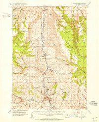
~ Picture OR topo map, 1:62500 scale, 15 X 15 Minute, Historical, 1953, updated 1955
Picture, Oregon, USGS topographic map dated 1953.
Includes geographic coordinates (latitude and longitude). This topographic map is suitable for hiking, camping, and exploring, or framing it as a wall map.
Printed on-demand using high resolution imagery, on heavy weight and acid free paper, or alternatively on a variety of synthetic materials.
Topos available on paper, Waterproof, Poly, or Tyvek. Usually shipping rolled, unless combined with other folded maps in one order.
- Product Number: USGS-5545208
- Free digital map download (high-resolution, GeoPDF): Picture, Oregon (file size: 9 MB)
- Map Size: please refer to the dimensions of the GeoPDF map above
- Weight (paper map): ca. 55 grams
- Map Type: POD USGS Topographic Map
- Map Series: HTMC
- Map Verison: Historical
- Cell ID: 60970
- Scan ID: 282788
- Imprint Year: 1955
- Woodland Tint: Yes
- Aerial Photo Year: 1946
- Datum: NAD27
- Map Projection: Polyconic
- Map published by United States Geological Survey
- Map Language: English
- Scanner Resolution: 600 dpi
- Map Cell Name: Picture Gorge
- Grid size: 15 X 15 Minute
- Date on map: 1953
- Map Scale: 1:62500
- Geographical region: Oregon, United States
Neighboring Maps:
All neighboring USGS topo maps are available for sale online at a variety of scales.
Spatial coverage:
Topo map Picture, Oregon, covers the geographical area associated the following places:
- Waller Reservoir Number Four - Middle Mountain - Mud Spring - Junction Springs - Birch Creek - Spring Creek - Buckhorn Creek - Frank Creek - Turtle Cove - Thorn Spring - Sheep Rock - Butler Basin - Thomas Condon Paleontology Center - Waterspout Gulch - Dam Number Three - Big Basin - Humphrey Ranch - Little Rattlesnake Creek - Indian Creek - Land's Inn Ranch Airport - Devils Gulch - Artman Basin - Goose Creek - Cathedral Rock - Sand Spring - Old Buckhorn Ranch - Mount Misery - Mule Pasture Spring - Lone Pine Trail - Deep Creek - Waller Reservoir Number One - Goose Rock - Hide and Seek Creek - Bull Canyon - Rattlesnake Creek - Hog Ridge - First Creek - Burnt Corral Springs - Johnny Creek - Johnny Kirk Spring - Goose Rock Bridge - Bone Creek - Old Kennedy Cabin (historical) - Harry Creek - Waller Reservoir Number Two - Basin Post Office (historical) - Jerrys Ridge - John Day Fossil Beds National Monument Cant Ranch Museum - Mule Gulch - Willow Spring - Deep Creek - Shirttail Creek - Jerrys Draw - Bear Creek - Saddle Camp - Burnt Corral Creek - Branson Creek - Waller Reservoir Number Three - Sugarloaf - Windy Point - Old Johnson Cabin - Rock Creek - Cottonwood Creek - Johnson Creek - Fossil Creek - John Day Fossil Beds National Monument - McGinnis Creek - Mountain Creek - Black Snag Springs - Deer Gulch - Cal Smith Spring - National Park Service John Day Fossil Beds National Monument Ranger Station - Hole in the Ground - Sheep Gulch - Old Watkins Cabin (historical) - Sunflower Flat - Gus Creek - Miller Flat - Old Armunger Cabin - Juniper Gulch - McCarty Creek - Rose Creek - Holmes Creek - Tri-Creek Ranch - Dick Creek - Erickson Mill - Picture Gorge - Mascall Ranch - Lost Fawn Creek - Longview Ranch Airport - Rimrock Spring
- Map Area ID: AREA44.7544.5-119.75-119.5
- Northwest corner Lat/Long code: USGSNW44.75-119.75
- Northeast corner Lat/Long code: USGSNE44.75-119.5
- Southwest corner Lat/Long code: USGSSW44.5-119.75
- Southeast corner Lat/Long code: USGSSE44.5-119.5
- Northern map edge Latitude: 44.75
- Southern map edge Latitude: 44.5
- Western map edge Longitude: -119.75
- Eastern map edge Longitude: -119.5


