
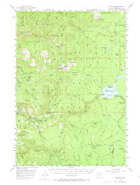
~ High Rock OR topo map, 1:62500 scale, 15 X 15 Minute, Historical, 1956, updated 1974
High Rock, Oregon, USGS topographic map dated 1956.
Includes geographic coordinates (latitude and longitude). This topographic map is suitable for hiking, camping, and exploring, or framing it as a wall map.
Printed on-demand using high resolution imagery, on heavy weight and acid free paper, or alternatively on a variety of synthetic materials.
Topos available on paper, Waterproof, Poly, or Tyvek. Usually shipping rolled, unless combined with other folded maps in one order.
- Product Number: USGS-5544826
- Free digital map download (high-resolution, GeoPDF): High Rock, Oregon (file size: 8 MB)
- Map Size: please refer to the dimensions of the GeoPDF map above
- Weight (paper map): ca. 55 grams
- Map Type: POD USGS Topographic Map
- Map Series: HTMC
- Map Verison: Historical
- Cell ID: 55324
- Scan ID: 282576
- Imprint Year: 1974
- Woodland Tint: Yes
- Aerial Photo Year: 1954
- Field Check Year: 1956
- Datum: NAD27
- Map Projection: Polyconic
- Map published by United States Geological Survey
- Map Language: English
- Scanner Resolution: 600 dpi
- Map Cell Name: High Rock
- Grid size: 15 X 15 Minute
- Date on map: 1956
- Map Scale: 1:62500
- Geographical region: Oregon, United States
Neighboring Maps:
All neighboring USGS topo maps are available for sale online at a variety of scales.
Spatial coverage:
Topo map High Rock, Oregon, covers the geographical area associated the following places:
- Buck Lake - Final Falls - Mount Mitchell - Inch Creek - Fir Tree Creek - Pan Creek - Rock Butte - Pot Creek Cabin - Timothy Lake Dam - Pine Point Recreation Site - Salmon Butte Trail - Shellrock Creek - Vanishing Falls - Cot Creek - Thunder Quarry - Skyline Alternate Trail - Cove Recreation Site - Buck Creek Trail - Basin Point - Rimtie Quarry - Black Wolf Meadows - Fir Tree Forest Camp - Indian Ridge - Hambone Butte - Stone Creek Gravel Pit - Lower Rock Lake - Anvil Lake - Snive Creek - Peavine Spring - Peavine Creek - Gone Creek Recreation Site - Wolf Creek - Frazier Fork Campground - South Fork Ridge Trail - String Creek - Summit Lake Recreation Site - Crater Creek - Linney Creek Recreation Site - Lightning Creek - Pyramid Lake - Spring Creek - Salmon Lake - Kelley Creek - Alligator Quarry - Black Wolf Meadow Creek - Frustration Falls - Basin Point Quarry - Signal Buttes - Canyon Creek - Hoodview Campground Boat Launch - Linney Creek - Oak Grove Butte - Dinger Creek - North Arm Recreation Site - Cottonwood Meadows - Harriet Lake Boat Launch - Splintercat Creek - Hideaway Falls - Sherar Burn - Dinger Lake - Skunk Creek - Lost Creek - Devils Spring - High Rock - Linney Butte - Jackpot Meadow - Frying Pan Lake - Kink Creek - Middle Rock Lake - Dry Creek Spring - Lake Harriet - Fire Spring - Devils Ridge Quarry - Hideaway Lake Recreation Site - Pot Creek Trail - Little Crater Lake Geological Area - Gone Creek Boat Launch - Sink Quarry - Dinger Creek Trail - Buck Creek - Salmon Butte - Steep Spring - Oak Fork Boat Launch - Cache Meadow - Rock Spring - Cottonwood Meadows Trail - Draw Creek - Round Wolf Pit - Warm Springs Meadow Trail - Wolf Peak - Devils Spring Creek - Cougar Creek - Iron Creek - Pot Creek - Buck Lake Gravel Pit - Anvil Creek - Shellrock Creek Recreation Site - Pine Point Boat Launch - Plaza Lake - Gee Zee Quarry
- Map Area ID: AREA45.2545-122-121.75
- Northwest corner Lat/Long code: USGSNW45.25-122
- Northeast corner Lat/Long code: USGSNE45.25-121.75
- Southwest corner Lat/Long code: USGSSW45-122
- Southeast corner Lat/Long code: USGSSE45-121.75
- Northern map edge Latitude: 45.25
- Southern map edge Latitude: 45
- Western map edge Longitude: -122
- Eastern map edge Longitude: -121.75


