
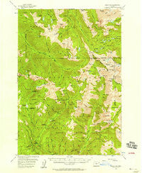
~ Eagle Cap OR topo map, 1:62500 scale, 15 X 15 Minute, Historical, 1954, updated 1958
Eagle Cap, Oregon, USGS topographic map dated 1954.
Includes geographic coordinates (latitude and longitude). This topographic map is suitable for hiking, camping, and exploring, or framing it as a wall map.
Printed on-demand using high resolution imagery, on heavy weight and acid free paper, or alternatively on a variety of synthetic materials.
Topos available on paper, Waterproof, Poly, or Tyvek. Usually shipping rolled, unless combined with other folded maps in one order.
- Product Number: USGS-5544572
- Free digital map download (high-resolution, GeoPDF): Eagle Cap, Oregon (file size: 11 MB)
- Map Size: please refer to the dimensions of the GeoPDF map above
- Weight (paper map): ca. 55 grams
- Map Type: POD USGS Topographic Map
- Map Series: HTMC
- Map Verison: Historical
- Cell ID: 53661
- Scan ID: 282441
- Imprint Year: 1958
- Woodland Tint: Yes
- Aerial Photo Year: 1953
- Field Check Year: 1954
- Datum: NAD27
- Map Projection: Polyconic
- Map published by United States Geological Survey
- Map Language: English
- Scanner Resolution: 600 dpi
- Map Cell Name: Eagle Cap
- Grid size: 15 X 15 Minute
- Date on map: 1954
- Map Scale: 1:62500
- Geographical region: Oregon, United States
Neighboring Maps:
All neighboring USGS topo maps are available for sale online at a variety of scales.
Spatial coverage:
Topo map Eagle Cap, Oregon, covers the geographical area associated the following places:
- Kettle Creek - Two Pan Trailhead - Moon Lake - West Eagle Trail - Lowry Gulch - Mammouth Spring - Cheval Lake - East Fork West Eagle Creek - Pine Lakes - East Eagle Mine - Tombstone Lake - Brown Mountain - Jackson Peak - Twin Canyon - Traverse Lake Dam - Last Chance Creek - Arrow Lake - Diamond Lake - Dennis Creek - Copper Creek Falls - Curtis Creek - Hudson Creek - Minam Lake Dam - Crater Lake - Olive Lake - Groover Spring - River Head Camp (historical) - Sky Lake - Ice Lake - Elk Creek - Pop Lake - Eagle Lake Dam - Dodge Creek - Bradley Creek Mine - Two Color Creek - Steiger Spring - Sacajawea Peak - Sullivan Creek - Lookout Spring - Elkhorn Creek - Mirror Lake - Phillips Ditch - Craig Mountain - Mud Spring - Dixie Creek - Two Color Guard Station - Pop Creek - Sunshine Lake - Trail Creek - Jack Creek - Two Color Horse Camp - Park Creek - Krag Peak - The Box - Upper Pine Lake - Frazier Pass - Prospect Lake - Echo Lake - Moccasin Lake - Bear Lake - Cougar Meadows - Glacier Pass - Boulder Park Recreation Site - Little Frazier Lake - Upper Pine Lake Dam - Truax Mountain - Craig Lake - Granite Cliff - Copper Creek - Little Pop Lake - Wallowa Mountains - Hawkins Pass - Crater Lake Dam - Hazel Mountain - Unit Lake - Heart Lake - Catched Two Lake - Katy Mountain - Benson Glacier - Glacier Mountain - Bennett Peak - Horseshoe Lake - Cow Creek - Matterhorn - Cusick Mountain - Little Boulder Creek - Gold King Creek - Main Creek Trail - Eagleton Post Office (historical) - Hummingbird Mountain - Copper Creek - Lilly Lake - Granite Gulch - West Eagle Horse Camp - Hazel Lake - East Fork Elk Creek - Glendenning Creek - Thistle Creek - Hidden Lake - Eagle Cap Wilderness
- Map Area ID: AREA45.2545-117.5-117.25
- Northwest corner Lat/Long code: USGSNW45.25-117.5
- Northeast corner Lat/Long code: USGSNE45.25-117.25
- Southwest corner Lat/Long code: USGSSW45-117.5
- Southeast corner Lat/Long code: USGSSE45-117.25
- Northern map edge Latitude: 45.25
- Southern map edge Latitude: 45
- Western map edge Longitude: -117.5
- Eastern map edge Longitude: -117.25


