
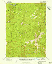
~ Collier Butte OR topo map, 1:62500 scale, 15 X 15 Minute, Historical, 1954, updated 1956
Collier Butte, Oregon, USGS topographic map dated 1954.
Includes geographic coordinates (latitude and longitude). This topographic map is suitable for hiking, camping, and exploring, or framing it as a wall map.
Printed on-demand using high resolution imagery, on heavy weight and acid free paper, or alternatively on a variety of synthetic materials.
Topos available on paper, Waterproof, Poly, or Tyvek. Usually shipping rolled, unless combined with other folded maps in one order.
- Product Number: USGS-5544418
- Free digital map download (high-resolution, GeoPDF): Collier Butte, Oregon (file size: 10 MB)
- Map Size: please refer to the dimensions of the GeoPDF map above
- Weight (paper map): ca. 55 grams
- Map Type: POD USGS Topographic Map
- Map Series: HTMC
- Map Verison: Historical
- Cell ID: 52807
- Scan ID: 282349
- Imprint Year: 1956
- Woodland Tint: Yes
- Aerial Photo Year: 1952
- Field Check Year: 1954
- Datum: NAD27
- Map Projection: Polyconic
- Map published by United States Geological Survey
- Map Language: English
- Scanner Resolution: 600 dpi
- Map Cell Name: Collier Butte
- Grid size: 15 X 15 Minute
- Date on map: 1954
- Map Scale: 1:62500
- Geographical region: Oregon, United States
Neighboring Maps:
All neighboring USGS topo maps are available for sale online at a variety of scales.
Spatial coverage:
Topo map Collier Butte, Oregon, covers the geographical area associated the following places:
- Hayes Eddy - Bluff Creek - Skookumhouse Butte - North Fork Collier Creek - Green Craggie - Fairview Mountain - Burt Camp - Three Tree Lookout (historical) - Upper Mislatnah Prairie - Indian Flat - Game Lake Lookout (historical) - Three Tree Camp (historical) - Mineral Spring - Rogue National Wild and Scenic River - Cedar Camp - Little Silver Creek - Wildhorse Prairie - Lately Prairie - Fairview Meadow - Snow Camp Meadow - Wildhorse Lookout - Wilson Cabin - Saddle Mountain - Collier Butte - Three Trees - Collier Creek - Blue Slide Creek - Bill Moore Creek - Quosatana Creek Riffle - Jacks Camp - Quosation Post Office (historical) - Tolman Ranch - Buzzards Roost - Huntley Spring - Humboldt Spring - Big Craggies Botanical Area - Big Craggies - Lawson Butte - Craggie Creek - Silver Creek - Horse Sign Butte - Fry Place - Darling Creek - Fry Landing - Mineral Hill - Bradford Creek - Forest Creek - High Prairie - Skookumhouse Canyon - Snow Camp Trail - Horse Sign Creek - Collier Bar - Curry County - Indigo Creek - Mislatnah Peak - Windy Creek - Quosatana Butte - Quosatana Creek - Sizeable Stream - Sugarloaf Mountain - Black Rock Creek - Coal Riffle - Bowman Ranch - Mislatnah Creek - Elko Camp Recreation Site - Brandon Camp - Quosatana Campground Boat Ramp - Brookings Division - South Fork Collier Creek - Bacon Flat Riffle - Pine Flat Creek - Tincup Creek - Quosatana Recreation Site - Wildhorse Recreation Site - Conners Place - Mislatnah Lookout (historical) - Humboldt Spring - Meadow Creek - Sourdough Camp (historical) - Eagle Creek Trail - Snow Camp Mountain - Fairview Camp - Tolman Creek - Game Lake - Fall Creek - Big Fish Riffle - Humboldt Spring Camp (historical) - Game Lake Recreation Site - South Fork Lawson Creek - Jacoby Butte - Stack Yards - East Fork Pistol River - Hazel Camp - Illinois National Wild and Scenic River - Lowery Riffle - Cedar Creek - Windy Valley - Horse Sign Creek Rapids - Panther Lake - Fritsche Cabin
- Map Area ID: AREA42.542.25-124.25-124
- Northwest corner Lat/Long code: USGSNW42.5-124.25
- Northeast corner Lat/Long code: USGSNE42.5-124
- Southwest corner Lat/Long code: USGSSW42.25-124.25
- Southeast corner Lat/Long code: USGSSE42.25-124
- Northern map edge Latitude: 42.5
- Southern map edge Latitude: 42.25
- Western map edge Longitude: -124.25
- Eastern map edge Longitude: -124


