
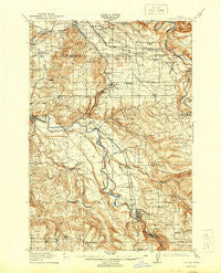
~ Boring OR topo map, 1:62500 scale, 15 X 15 Minute, Historical, 1914, updated 1944
Boring, Oregon, USGS topographic map dated 1914.
Includes geographic coordinates (latitude and longitude). This topographic map is suitable for hiking, camping, and exploring, or framing it as a wall map.
Printed on-demand using high resolution imagery, on heavy weight and acid free paper, or alternatively on a variety of synthetic materials.
Topos available on paper, Waterproof, Poly, or Tyvek. Usually shipping rolled, unless combined with other folded maps in one order.
- Product Number: USGS-5544290
- Free digital map download (high-resolution, GeoPDF): Boring, Oregon (file size: 11 MB)
- Map Size: please refer to the dimensions of the GeoPDF map above
- Weight (paper map): ca. 55 grams
- Map Type: POD USGS Topographic Map
- Map Series: HTMC
- Map Verison: Historical
- Cell ID: 62114
- Scan ID: 282271
- Imprint Year: 1944
- Survey Year: 1912
- Datum: Unstated
- Map Projection: Unstated
- Map published by United States Geological Survey
- Map Language: English
- Scanner Resolution: 600 dpi
- Map Cell Name: Sandy
- Grid size: 15 X 15 Minute
- Date on map: 1914
- Map Scale: 1:62500
- Geographical region: Oregon, United States
Neighboring Maps:
All neighboring USGS topo maps are available for sale online at a variety of scales.
Spatial coverage:
Topo map Boring, Oregon, covers the geographical area associated the following places:
- Powell Valley - Eagle Creek - Sandy - North Highland - Damascus Heights - Boring - Pleasant Home - Cedarhurst Park - Estacada - Cottrell - Garfield (historical) - Viola - Gresham - Carver - Currinsville - Springwater - Barton - Paradise Park - Kelso - Redland - Hillsview - Deep Creek (historical) - Logan - Damascus - Tracy - Orient
- Map Area ID: AREA45.545.25-122.5-122.25
- Northwest corner Lat/Long code: USGSNW45.5-122.5
- Northeast corner Lat/Long code: USGSNE45.5-122.25
- Southwest corner Lat/Long code: USGSSW45.25-122.5
- Southeast corner Lat/Long code: USGSSE45.25-122.25
- Northern map edge Latitude: 45.5
- Southern map edge Latitude: 45.25
- Western map edge Longitude: -122.5
- Eastern map edge Longitude: -122.25


